Austin's Limestone Doesn't Surprise Us. We've Already Mapped It.
RTK-verified excavation from pool shells to foundation pads. Hydraulic rock hammer purpose-built for Hill Country geology. Every cut measured to centimeter accuracy — documented in 3D before, during, and after.
Precision cuts.
Verified results.
Excavation in Central Texas means working with some of the hardest geology in the country. Limestone as shallow as 18 inches below grade has blown timelines, broken rental equipment, and torpedoed project budgets for contractors who didn't see it coming.
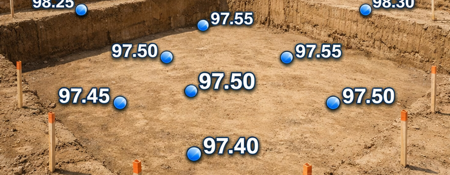
ClearGround scans the subsurface before the first bucket moves. Rock shelves get located. Grade differentials get modeled. Every cubic yard removed is documented in 3D and verified by RTK — so the number we bill is the number we can prove.
Pool Shell Excavation
Precision pool digs in Hill Country limestone. The hydraulic rock hammer carves shell profiles to spec — including complex freeform designs — with low-vibration operation next to existing slabs, patios, and foundations.
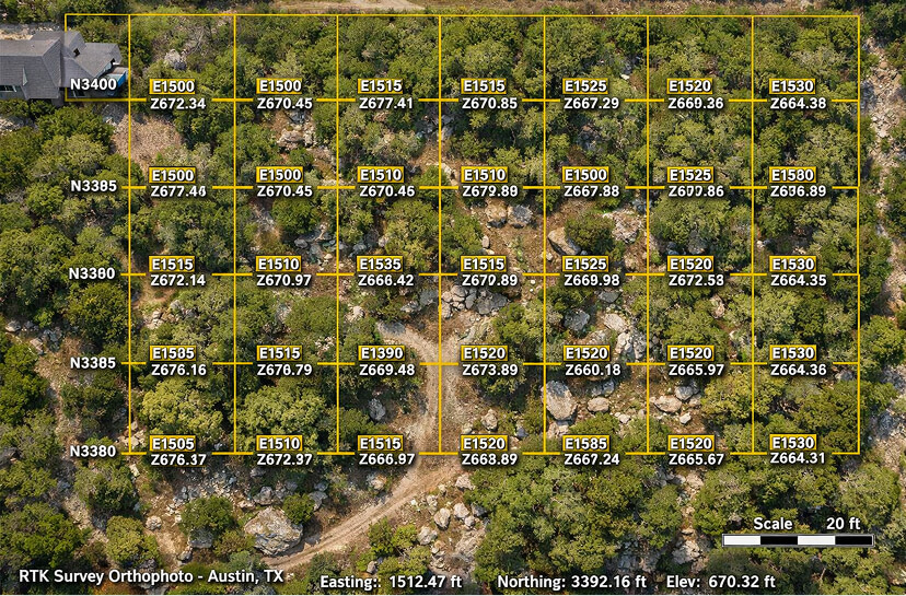
Before your crew mobilizes, our RTK pre-scan locates the limestone shelf in 3D. No surprises. No broken equipment. No blown timelines next to a neighbor's foundation.
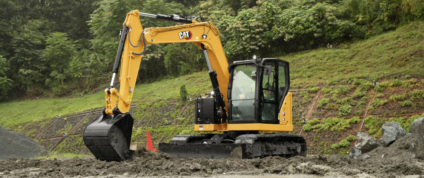
CAT 308E2 CR · NPK GH6 Rock Hammer
RTK Pre-Scan · Low-Vibration Technique
Limestone & Rock Excavation
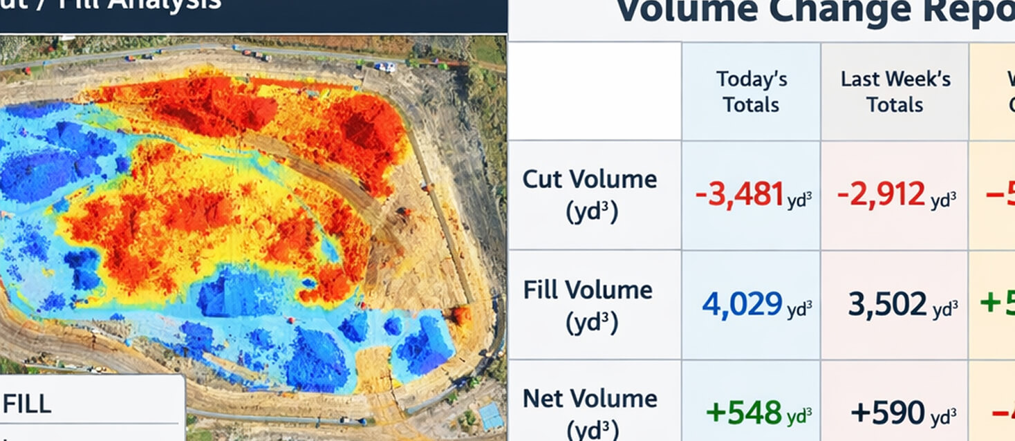
Hard limestone as shallow as 18 inches below grade. Standard rental equipment breaks on it. ClearGround's hydraulic rock hammer handles the geology nobody warns you about — with real-time volumetric tracking so every cubic yard removed is measured and documented, not estimated after the fact.
We run the RTK pre-scan before quoting. You see the rock shelf in 3D. You approve the scope. The estimate doesn't change when we find what we already knew was there.
CAT 308E2 CR · NPK GH6 1,500 LB Hammer
RTK Volumetric Tracking · On-Site Rock Milling Available
Large rock cuts $100,000+
Site Prep & Pad Prep
Residential and light commercial pad creation. Cut and fill to engineered grade with RTK-verified elevation checks throughout the process — not just a final survey after the fact. The InSite Elevation Pro workflow confirms drainage performance before the inspector arrives.
CAT 308E2 CR · GPS Grade Control
InSite Elevation Pro · Drainage Verification
($25K+ where rock/engineered fill applies)
Foundation Excavation
Pier holes, strip footings, and full perimeter excavation for single-family footprints. Every footing documented with as-built measurements before concrete is poured — so the foundation record exists permanently, not just in someone's memory.
CAT 308E2 CR · Auger Attachment
As-Built LiDAR Documentation
Single-family residential footprint.
Utility Trenching
Plumbing, electrical, and drainage line trenches dug to specification. LiDAR as-built scans before backfill document exact pipe locations, depths, and routing permanently — so the buried infrastructure is on record, not just assumed from the original drawings.
CAT 308E2 CR · LiDAR Documentation
As-Built Scans Before Backfill
Grading & Drainage Prep
Final grade to engineered drainage plan. Water flow modeling confirms drainage performance before the inspector arrives — not after. Austin's streamlined drainage review documentation is standard on every ClearGround grading job, not an add-on.
CAT 308E2 CR · InSite Elevation Pro
Drainage Review Documentation Included
Residential lot grading to engineered drainage plan.
Tight Lot & Legacy Tree Excavation
50×100-foot lots. Five-foot setbacks. Protected heritage oaks. Full-size excavators can't fit. The compact-radius CAT 308E2 CR operates in spaces standard machines can't access — and the RTK pre-scan maps every CRZ boundary before iron rolls near a protected tree.
Austin's Heritage Tree Ordinance isn't optional. ClearGround documents CRZ compliance before, during, and after — giving you the paper trail that protects the project, not just the trees.
CAT 308E2 CR (Compact Radius / Zero Tail Swing)
Heritage Tree CRZ Mapping · Arborist Coordination
Residential & Light Commercial
A retaining wall fails at the base and the drainage — the two things you can't see once it's backfilled. So we scan the subgrade before we dig and document the drainage before we bury it. You get a wall built on engineered ground, and a verified record proving what's behind the face.
CAT 308E2 CR (Compact Radius / Zero Tail Swing)
Heritage Tree CRZ Mapping · Arborist Coordination
What will excavation
on your site cost?
Get a 2026 price range for Austin & Hill Country excavation in 60 seconds. Every estimate includes an RTK pre-dig site scan that maps your rock shelf in 3D — so you know exactly what’s underground before we dig.
- Pre-dig RTK rock-shelf scan
- Real-time volumetric tracking
- 48-hr as-built 3D Digital Twin
- Veteran operator + all fuel
Planning estimate only. Final pricing requires an RTK pre-dig site scan mapping your rock shelf in 3D. Hill Country limestone, slope, and access conditions may shift price within the published range. Quote turnaround: 48 hours.
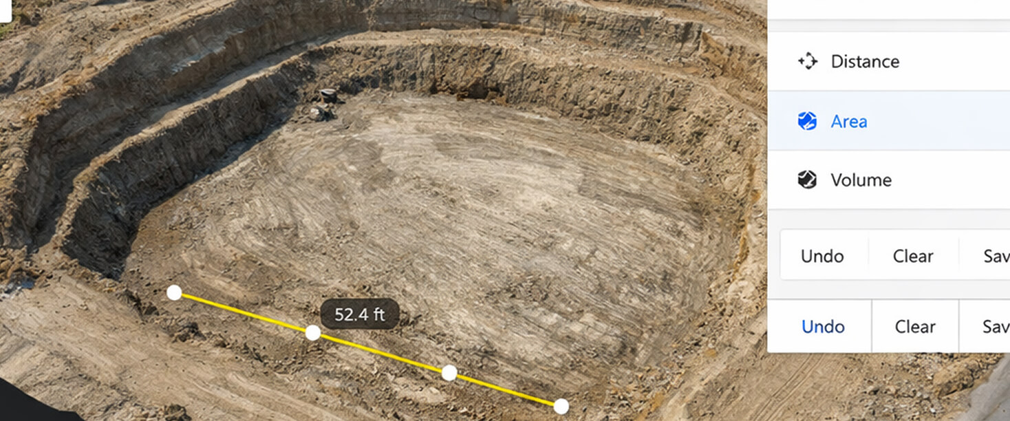
Every excavation project includes pre-dig RTK drone survey, real-time volumetric tracking, and as-built digital twin delivery within 48 hours of completion. You're not buying excavation hours. You're buying a documented, dispute-proof excavation with 3D verification.
At Any Phase of Your Project —
Get an Unbiased View of Your Site
We Scan Before We Dig.
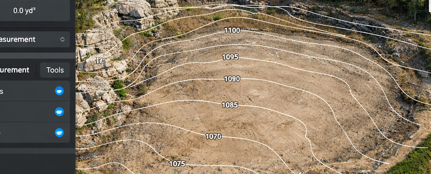
Most contractors show up with a machine and a gut feeling. We show up with a Mavic 3 Enterprise RTK drone that maps your site to ±0.5cm accuracy before a single bucket moves. Rock shelves get located. Grade differentials get modeled. Subsurface limestone depth gets mapped in 3D. You see the site conditions before we quote.
Excavation is often phase two or three of a multi-service project. One mobilization handles multiple phases — clearing, rock milling, excavation, and grading in sequence — with a verified handoff at each transition.
Every photo and every frame is from real ClearGround job sites. No stock. No renders.
Built for the people
who build what's next.
"Hit limestone at 18 inches, blew the timeline, broke the equipment, and the homeowner is furious."
We eat limestone for breakfast. ClearGround maps the rock shelf in 3D before your crew mobilizes — so you quote accurately, mobilize once, and deliver on time. The hydraulic rock hammer handles what standard rental equipment can't. Low-vibration technique protects adjacent foundations. Every cubic yard documented in 3D.
See how we solve that"Drainage review failure. Killed a heritage tree. Permitting delay destroyed the pro forma."
One mobilization covers the full sequence: selective demo, clearing, excavation, grading, drainage verification. Heritage trees CRZ-flagged before clearing begins. Grade verified to engineered drainage plan via InSite before your drainage review submittal. The documentation trail that survives city review is standard — not an add-on.
See how we solve that"Survey crew takes 4 weeks to mobilize. As-built data won't integrate into CAD/BIM."
Survey-grade as-built data that integrates into your CAD/BIM workflow. RTK drone capture delivered as .dwg, .rvt, or point cloud. Georeferenced. 48-hour turnaround. We mobilize faster than traditional survey crews and deliver file formats your workflow already uses. Construction monitoring on demand.
See the data specsThe iron behind
the precision.
Compact-radius mini excavator built for tight residential and urban sites. Zero tail swing operates where full-size machines can't fit — 50-foot infill lots, backyard pool digs, narrow urban sites adjacent to existing structures.
1,500 lb class hydraulic hammer purpose-built for Hill Country limestone. Matched to the CAT 308's hydraulic flow for maximum impact energy. Low-vibration technique critical for work adjacent to existing foundations, pool shells, and slabs.
Survey-grade drone platform delivering centimeter-accurate terrain models. Captures pre-dig conditions, monitors progress, and produces as-built documentation — all georeferenced and integrated with DroneDeploy and InSite Elevation Pro.
Book Your Free
Site Scan
Every project starts with an RTK drone scan of your site. We fly it, build your 3D model, and deliver a fixed-price proposal — all before you commit to anything.
48-hour mobilization · Austin & Hill Country · Verified before we quote