WE SCAN BEFORE WE CLEAR OR DIG. WE PROVE WHAT WE MOVE.
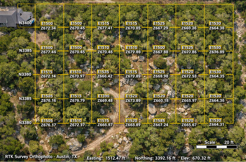
Survey-grade RTK drone mapping delivers ±0.5cm accuracy before, during, and after every project. Every cubic yard billed is a cubic yard verified. Every deliverable is georeferenced, timestamped, and CAD/BIM-ready.
Austin, TX · Hill Country · Lakeway
Dripping Springs · Westlake · Round Rock
By the Numbers
±0.5cm
RTK Horizontal Accuracy
48hr
Site Scan to Deliverable
3D
Georeferenced Digital Twin
.dwg
CAD / BIM Export Ready
The Tech Stack
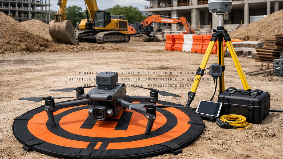
SURVEY-GRADE HARDWARE. PRODUCTION-GRADE SOFTWARE.
Every tool in our stack was selected for one purpose: to generate data that holds up in billing disputes, engineering reviews, and insurance claims. No consumer gear. No guesswork.
Aerial Capture
DJI Mavic 3 Enterprise RTK
Real-Time Kinematic corrections provide centimeter-level horizontal and vertical accuracy without ground control points. Pre-programmed mapping missions capture 100+ georeferenced images per flight in under 15 minutes.
RTK positioning · 56× zoom · 4/3 CMOS sensor
Mechanical shutter · FAA Part 107 certified pilots
3D Modeling & Hosting
DroneDeploy
Drone imagery processed into georeferenced 3D models, orthomosaics, and elevation maps. Hosted on a shareable web platform — your team, your engineer, your lender can open it in any browser. No software install required.
Orthomosaic · Point Cloud · 3D Mesh
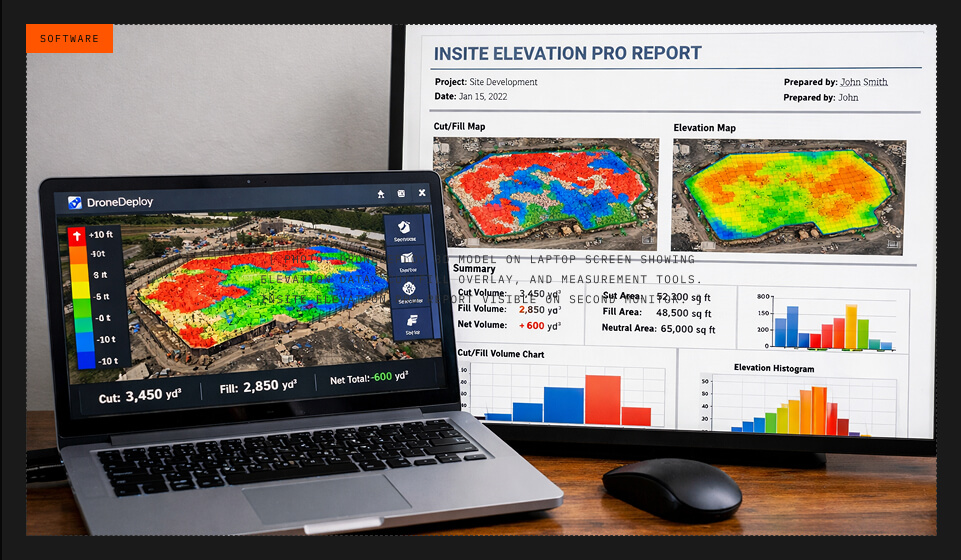
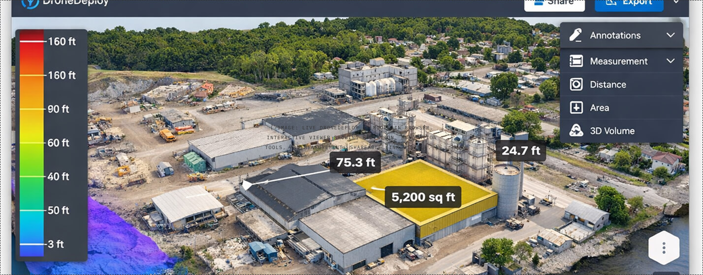
Web-based viewer · Annotation tools · Measurement
Earthwork Volumetrics
InSite Elevation Pro
Industry-standard takeoff and volumetric analysis. Calculates cut/fill quantities from RTK survey data against design surfaces. Every cubic yard verified mathematically before the invoice goes out.
iPhone Pro LiDAR captures utility trenches, footings, and subsurface installations before backfill. Canvas converts LiDAR scans into .dwg and .rvt files when your architect or GC requires BIM-level as-built data.
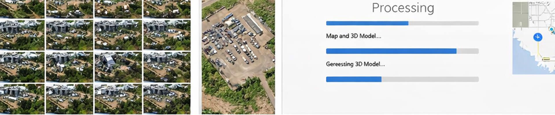
FROM FLIGHT TO DELIVERABLE. 48 HOURS. NOT 4 WEEKS.
Traditional survey crews take 2–4 weeks and charge $3,000–$8,000. Our RTK drone survey captures the same data in 15 minutes, processes overnight, and delivers a shareable 3D model within 48 hours.
01
Request
Site visit scheduled. Flight plan programmed for your specific parcel boundaries.
Imagery uploaded to DroneDeploy. Point cloud, orthomosaic, and 3D model generated.
→
04
Analysis
InSite Elevation Pro runs cut/fill against design surface. Volumetrics verified.
→
05
Delivery
Shareable link, .dwg/.rvt exports, and signed accuracy report delivered to your team.
This is how every ClearGround project works
AT ANY PHASE OF YOUR PROJECT GET AN UNBIASED VIEW OF YOUR SITE
Pre-Mobilization
PHASE 01 — BEFORE THE FIRST BUCKET
WE SCAN BEFORE WE DIG.
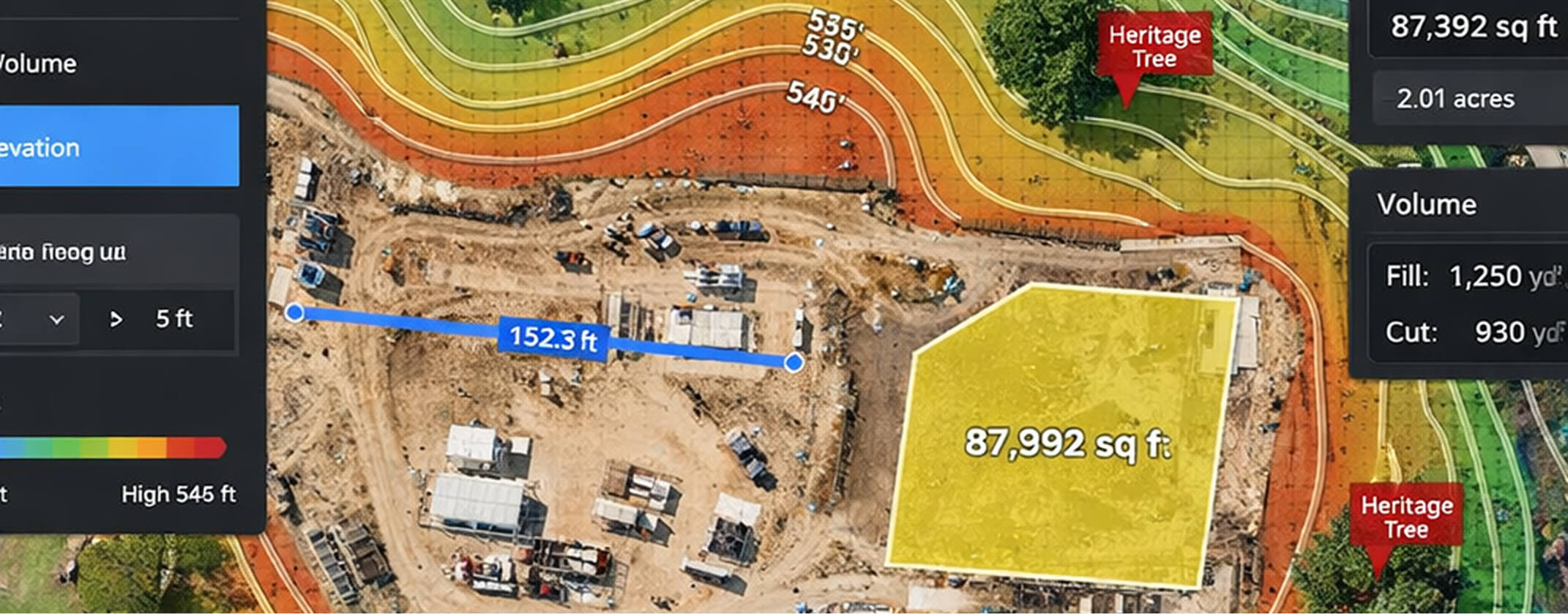
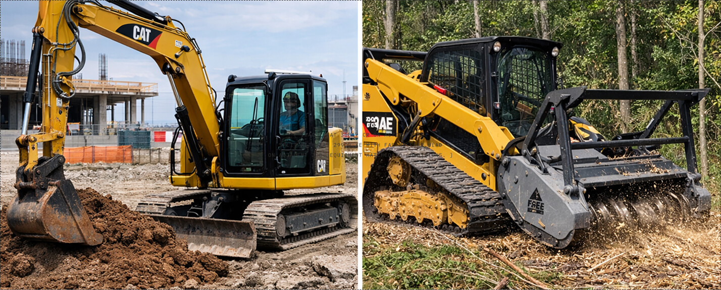
Most contractors show up with a machine and a gut feeling. We show up with a Mavic 3 Enterprise RTK drone that maps your site to ±0.5cm horizontal accuracy before a single bucket moves. Heritage trees get a Critical Root Zone boundary. Drainage flow lines get modeled. Rock shelves get located. Every variable that causes change orders on other jobs gets accounted for on this one.
± 0.5CM HORIZONTAL ACCURACY · 48-HR MOBILIZATION · LAS POINT CLOUD + GEOTIFF ORTHOPHOTO
Site Prep
PHASE 02 — IRON ON THE GROUND
RIGHT MACHINE, RIGHT PROBLEM.
Not every lot needs the same iron. A tight Austin infill with heritage trees calls for a different approach than a Hill Country site with exposed limestone shelves. We spec the right machine for your specific conditions — CAT 308E2 CR for precision excavation, CAT 299D3 XE for clearing and grading, FAE mulcher for brush and rock, NPK GH6 hydraulic hammer when the geology fights back.
Most contractors discover problems too late. We don't. Every Friday, our team flies the site, updates the digital twin, and sends you a verified progress report — cut/fill delta, grade confirmation, and a timestamp you can share with your client, your engineer, or your lender. No surprises. No disputes. Just data, every week, on schedule.
When the job is done, you don't get a handshake and a gut feeling. You get a signed accuracy report, a CAD/BIM-ready as-built digital twin, and zero disputed yardage. Every cubic yard accounted for. Every grade verified. Documentation that holds up in any conversation — with your client, your engineer, or your GC.
AS-BUILT DIGITAL TWIN · SIGNED ACCURACY REPORT · CAD/BIM READY · ZERO DISPUTED YARDAGE
What You Actually Receive
PHASE 05 — THE DELIVERABLE
THIS IS WHAT WE HAND EVERY CLIENT.
A georeferenced 3D model of your site, hosted on DroneDeploy, shareable with anyone on your team. Measurable. Permanent. Not a PDF. Not a photo. A living digital twin you can return to at any point in the project lifecycle. Export to .dwg, .rvt, or share a browser link — whatever your workflow requires.
GEOREFERENCED 3D MODEL · DRONEDEPLOY PLATFORM · SHAREABLE · MEASURABLE · PERMANENT
1/5
2/5
3/5
4/5
5/5
Data Deliverables
EVERY PROJECT PRODUCES THESE DELIVERABLES.
ClearGround's digital deliverables are professional line items — not freebies. Every project includes these as standard, with ownership and usage rights clearly defined.
◎
3D Digital Twin
Georeferenced orthomosaic and point-cloud model generated via DJI Mavic 3 Enterprise RTK. Hosted on DroneDeploy with shareable web viewer.
.las point cloud · GeoTIFF orthomosaic
DroneDeploy web viewer · Browser-based
△
Earthwork Volumetrics
Quantified cut/fill reports generated via InSite Elevation Pro, verified against initial RTK site scans. The system of record for billing.
InSite Elevation Pro report
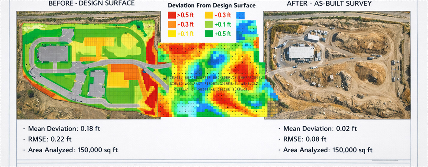
Cut/fill quantities · Design surface comparison
⊞
Sub-Surface Verification
LiDAR-based 3D scans of all utility trenches, footings, and subsurface installations prior to backfill. Your permanent "X-ray" of what's underground.
Weekly verified progress reports with updated 3D model, cut/fill delta, production tracking, and look-ahead. Delivered every Friday via shared link.
DroneDeploy link · PDF summary
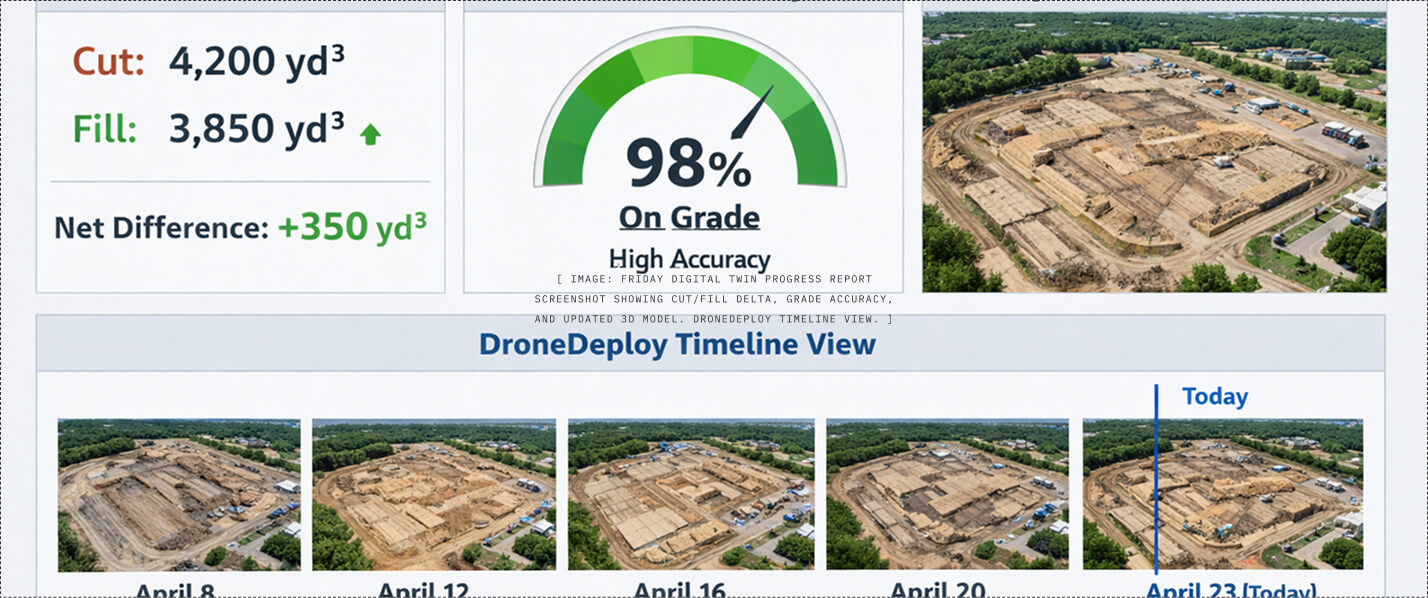
Volumetric delta · Grade verification
⊘
Signed Accuracy Report
Final project documentation with certified accuracy statement. Your proof that the work was done to plan, not to memory. Holds up in any review.
Signed accuracy certification
Before/after comparison · Final quantities
Technical Specifications
THE SPEC SHEET. NOT MARKETING FLUFF.
Specification
Detail
Why It Matters
Horizontal Accuracy
±0.5cm with RTK corrections
Eliminates disputed yardage. Accurate enough for civil engineering grade checks.
Vertical Accuracy
±1.0cm with RTK corrections
Critical for cut/fill volumetrics and drainage flow modeling.
Ground Control Points
Not required (RTK positioning)
Saves 2–3 hours per site. No survey crew needed for GCP placement.
Flight Time per Site
10–15 minutes automated
Minimal site disruption. Flight happens while crew mobilizes equipment.
Processing Time
Same-day to 24 hours
DroneDeploy cloud processing. No local hardware bottleneck.
Deliverable Turnaround
48 hours from flight to report
Traditional surveys take 2–4 weeks. This changes the project timeline.
Output Formats
.las, .laz, GeoTIFF, .dwg, .rvt, .obj
Native import into AutoCAD, Civil 3D, Revit, Procore, and most GIS platforms.
Coordinate System
NAD83 / WGS84 (configurable)
Matches your engineer's datum. No coordinate translation errors.
Drone Operations
FAA Part 107 certified pilots
Fully legal. Fully insured. All flights comply with FAA regulations.
Data Hosting
DroneDeploy cloud (perpetual access)
No software installs. Shareable via browser link. Annotations persist.
Data Ownership & Terms
YOUR DATA. CLEARLY DEFINED.
Every ClearGround project includes clear terms on data ownership, usage rights, and liability boundaries. No ambiguity. No surprises.
Data as System of Record
In the event of a dispute regarding soil volume, rock removal, or material imported, ClearGround's RTK-verified drone data and InSite reports serve as the primary system of record for billing. This stops the "my guy said he moved more dirt" argument before it starts.
Pre-Backfill Verification
Once a utility or footing is backfilled, the SiteScape/LiDAR scan constitutes the final evidence of as-built conditions. Client has 24 hours post-scan to dispute installation quality before backfill occurs.
Intellectual Property
ClearGround retains all IP rights to raw data, flight paths, and processing methodologies. Upon final payment, client receives a non-exclusive, perpetual license to use deliverables for maintenance, repair, and marketing of the specific project site.
Liability Boundaries
Deliverables represent as-built conditions at a specific timestamp. ClearGround is not liable for site changes occurring between scheduled scans. BIM models do not supersede stamped drawings of the Engineer of Record or Architect.
Professional Standard of Care
All digital captures performed using industry-standard RTK corrections to ensure centimeter-level accuracy. All drone operations conducted by FAA Part 107 certified pilots in compliance with federal regulations.
Marketing Rights
Unless otherwise agreed in writing, ClearGround reserves the right to use anonymized site scans and time-lapse footage for marketing and portfolio purposes. Client data is never shared with identifiable details without consent.
Who This Is For
EVERY ICP. DIFFERENT DATA.
The same technology platform, adapted to what each client actually needs from it. The data is the constant. The framing changes.
Pool & Estate Builders
See Where Rock Is Before You Quote
RTK pre-scan reveals limestone shelves, drainage paths, and subsurface obstacles before your crew hits something unexpected at 18 inches.
Before/after digital twin documents the full clearing transformation. Share with your landscaper, insurance agent, or neighbor who wants the same result.
.dwg/.rvt exports that integrate directly into your CAD/BIM pipeline. Point cloud, volumetrics, and as-built documentation without waiting 4 weeks for a survey crew.
Book a free site scan. We'll fly your site, generate the 3D model, and show you exactly what the data looks like — before you commit to anything. No sales pitch. Just data.