


Dense forest with a defined next use. We clear it, prepare the surface, and verify every acre in 3D.
Forest Clearing
& Land Preparation
Forested acreage — cedar thicket, mixed canopy, mature woodland — cleared comprehensively in a single machine pass and left in a prepared state for what comes next: cabin sites, ranch roads, agricultural conversion, rural development access, landscape installation. Everything above grade is mulched in place. The surface is open, stable, and drone-verified before the next phase of work begins.
Cleared. Prepared.
Ready for What's Next.
Forest Clearing & Land Preparation occupies the ground between Field & Brush Clearing — which handles undergrowth and invasive species on otherwise open land — and Land Reclamation, which delivers bare-dirt construction-ready grade. The output is a comprehensively cleared forested surface with mulch in place, suitable for a defined next use without requiring full reclamation.
What It Delivers
Construction-Ready Grade
Eight Next Uses.
One Clearing Method.
The clearing scope and equipment are identical regardless of what the land becomes after. What changes is the preservation plan — which trees stay, where clearing zones begin and end — all defined from the RTK site scan before any machine rolls.
Clearing the immediate footprint, access road corridor, and defensible space buffer for a cabin, barndominium, or rural outbuilding. RTK survey identifies the optimal building envelope within the existing canopy before clearing begins — so the plan reflects the terrain, not a guess from the road.
Cutting a road corridor through forested acreage — width and alignment set by terrain analysis from the drone survey. FAE head handles mature cedar and mixed trees along the corridor. Drone-verified corridor width throughout. Stable mulched surface ready for graveling or rock milling.
Converting forested or cedar-dominated land to hay fields, improved pasture, row crops, or orchard preparation. Comprehensive clearing with preservation of water features and soil structure. Native grass seed bank activated by clearing — not buried under bare soil.
Clearing forested acreage for solar installation, water storage infrastructure, ag equipment staging, or utility corridor access. Mulch-in-place leaves the surface stable before installation — no bare-dirt erosion between clearing and construction. RTK confirms clear area dimensions against infrastructure footprint.
Initial clearing of forested land ahead of subdivision layout, lot staking, and infrastructure design. Makes land visible, survey-accessible, and machine-navigable before grading begins. The post-clearing Digital Twin serves as the existing conditions baseline for the full development scope.
Creating ATV corridors, shooting lanes, walking trail networks, or recreational clearings within forested acreage. Selective clearing preserves tree canopy and habitat structure while opening specific corridors. Precision alignment cutting from drone-defined axis maps.
Clearing forested sections of a Hill Country estate for landscape installation — opening terrain, revealing views, establishing areas for native plantings, hardscape, or pool and entertainment infrastructure. Often Phase 1 before pool excavation or foundation work on estate lots.
Clearing utility easements, power line corridors, pipeline ROW, and access easements through forested acreage. RTK boundary documentation confirms clearing stayed within easement limits — critical for legal compliance on shared or encumbered land. Verified in the post-clearing scan.
Six Forest Clearing
Configurations
Forest clearing scope varies by canopy density, trunk diameter, terrain, and preservation requirements. Every project starts with a site scan that maps all four variables — so price and timeline are set from data before the machine arrives.
Closed-canopy cedar monoculture or mixed forest — 6–14"+ trunk diameter, full canopy, no light at ground level. One pass opens the surface completely. The most dramatic transformation in the portfolio and the most machine hours per acre.
Trunk diameter above 10" processes at roughly half the rate of 6" trees. No-daylight canopy limits machine visibility and pass speed. Intermixed hardwood and cedar requires more operator judgment than uniform stands. Rocky limestone terrain adds navigation complexity and head wear.
Mixed-age stands combining mature trees, mid-story cedar, undergrowth brush, and open patches — the typical condition of Hill Country acreage partially managed or transitioned from agricultural use over 15–25 years. Variable density mapped zone by zone from the site scan.
Irregular density patterns reduce machine efficiency versus uniform stands. Properties with significant preservation requirements create transition areas needing careful operator work. Mixed species including thorny brush slow the FAE head more than single-species cedar.
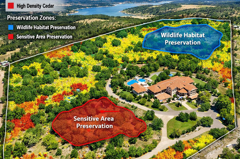
Clearing that removes targeted species or density while preserving specific trees, habitat structure, or canopy zones. Common on estate properties where the goal is a managed, park-like forest — or on development sites where heritage trees, creek setbacks, or HOA covenants mandate precise clearing boundaries.
Selective work requires more operator judgment and slower speeds — the machine continuously navigates around preserved trees. Complex preservation plans with multiple species designations add planning time. Austin Heritage Tree compliance adds documentation requirements addressed in the pre-clearing RTK survey.
20+ acres of forest clearing for subdivision development, large-acreage agricultural conversion, or estate-scale restoration. Systematic zone-based clearing with phased mobilization available. Volume pricing significantly reduces per-acre cost on larger projects.
Phased projects across multiple mobilizations carry a per-mobilization cost. Properties with distinct density zones require separate planning for each. Interim progress documentation for stakeholders or permitting adds drone flight and processing time between phases.
Clearing adjacent to seasonal creeks, wet weather drainages, springs, and ponds with careful management of the riparian buffer zone. RTK drone mapping identifies drainage features and flow paths before clearing — so the plan respects natural hydrology rather than disrupting it.
Riparian terrain is inherently slower — slope transitions, wet soil, drainage crossings. Buffer preservation requirements create irregular clearing boundaries. TCEQ or county setback compliance documentation adds post-clearing reporting requirements.
Forest clearing on Austin-area properties subject to the Heritage Tree Ordinance — protected trees (19"+ for most species, 8"+ for live oak) must remain and their Critical Root Zones must stay undisturbed. Every protected tree and CRZ boundary mapped from the pre-clearing RTK survey, with the clearing plan built around those boundaries from the first pass.
Working within CRZ setbacks requires slower, more deliberate operation throughout. Multiple heritage trees create no-go zones that break up efficient passes. Austin DSD pre-submission surveys add a separate documentation deliverable. Floodplain overlay zones may require additional City of Austin coordination.
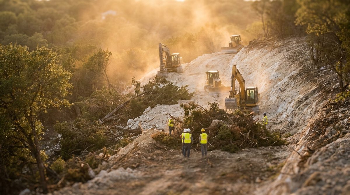
At Any Phase of Your Forest Clearing —
The Data Is There
The Plan Comes From the Canopy Data.
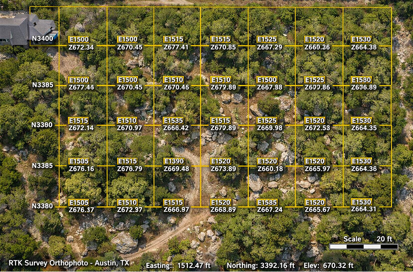
Before a machine is scheduled, a Mavic 3 Enterprise RTK drone maps the entire property at ±0.5cm accuracy. Tree canopy density is captured zone by zone. Individual specimen trees, creek features, drainage patterns, access constraints, and terrain grade changes are all identified and documented in the 3D model.
Heritage trees and CRZ boundaries — where applicable — are mapped to centimeter precision before the clearing plan is written. The plan defines every clearing zone, preservation zone, access corridor, and boundary exactly. You review and approve it. That approved plan is what the operator executes — not a general instruction to "clear the property."
Zone by Zone. Dense to Light. One Pass.
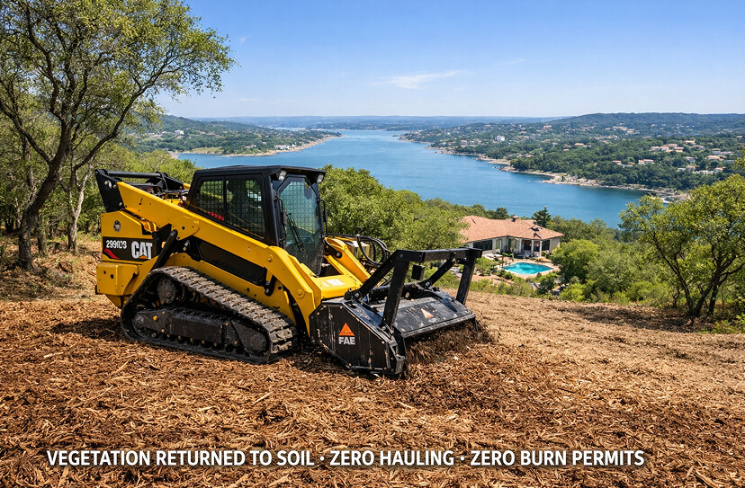
The CAT 299D3 XE with FAE mulching head works the property in the sequence the plan defines — denser zones first for machine efficiency, preservation boundaries maintained throughout. Trees, cedar, brush, and understory are processed in a single continuous pass. Material returns to the soil at chip level. Nothing is hauled. Nothing is burned.
The operator works with the full clearing plan — zone boundaries, preservation setbacks, access constraints — on their display throughout the job. The FAE head handles material from light undergrowth to 12"+ trunk diameter trees without equipment changes. One mobilization covers the full scope.
Progress Tracked. Boundaries Held.
On multi-day projects, mid-job drone scans document exactly what has been cleared and what remains. Preservation zone boundaries are verified against the plan — no encroachment into CRZs, creek buffers, or property-line setbacks. Zone progress by acre is captured and available remotely, so stakeholders see the state of the land without driving out to the site.
If a terrain feature changes the optimal sequence — an unexpected drainage crossing, a rock formation affecting access, a tree that wasn't visible in canopy imagery — it's documented and the plan adjusted before proceeding. Nothing continues on assumption.
Every Cleared Acre Measured. Every Preserved Tree Confirmed.
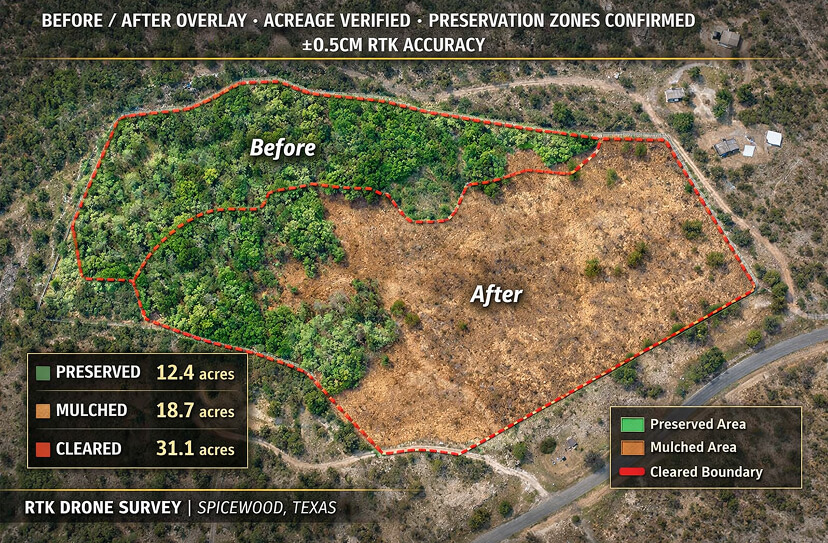
Final RTK drone survey maps the completed clearing at the same accuracy as the pre-clearing baseline. The before/after overlay is automatic — every cleared zone measured, every preservation boundary confirmed, every cleared acre documented against the invoice. If anything is off spec, it's caught before the machine demobilizes and addressed before the job closes.
For Heritage Tree compliance projects, the post-clearing scan generates documentation showing no CRZ encroachment occurred — useful for Austin DSD review or any future dispute. For development projects, the scan serves as the existing conditions baseline for the Phase 2 design scope.
Your 3D Record. The Baseline for What Comes Next.
Every forest clearing project delivers a complete 3D Digital Twin — before and after clearing — hosted on Pix4D Cloud, accessible from any browser via shareable link. The model is georeferenced and navigable in 3D with built-in measurement tools. No software download required. Share it with architects, engineers, landscape designers, surveyors, lenders, or your own records.
For projects where forest clearing is Phase 1 of a larger scope, the post-clearing Digital Twin becomes the existing conditions document for Land Reclamation, Excavation, or civil engineering design. Your design team gets a survey-grade 3D model of the cleared site — not a tape measure and a phone photo — which shortens the design phase and reduces surprises when the next contractor mobilizes.
Complimentary RTK Site Scan
for Qualifying Projects.
We're selectively offering free RTK drone surveys for qualifying forest clearing and land preparation projects in Austin and the Texas Hill Country. You get a geo-referenced 3D canopy model showing density by zone, drainage features, and specimen trees — before we quote a price. No obligation.
Real Projects.
Austin & Hill Country.
Every photo is from a real ClearGround job site. No stock. No renders.
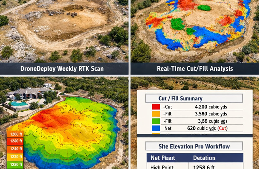
What Comes Next
Depends on the Goal.
Forest Clearing & Land Preparation is frequently Phase 1 of a larger scope. The post-clearing Digital Twin serves as the existing conditions baseline for whatever phase follows — and ClearGround handles the next phases directly.
When the cleared surface needs to become bare construction-ready dirt — root grubbing, rough grading, drainage modeling, rock milling, sub-base prep — Land Reclamation follows as Phase 2. The post-clearing RTK model is the existing conditions baseline, eliminating a redundant survey step and reducing design-phase surprises.
Land ReclamationPool shell excavation, foundation excavation, utility trenching, or limestone rock excavation follows forest clearing when the land is ready for below-grade work. The cleared surface gives equipment direct access. The post-clearing Digital Twin is the subgrade reference for the excavation scope.
ExcavationWhen the cleared forest is the destination — not a precursor to construction — annual maintenance clearing keeps the open surface managed as cedar regrows. Maintenance visits compare against the post-clearing baseline to target exactly where regrowth has occurred.
Forestry MulchingForest Clearing
Pricing — Central Texas
Clearing price is driven by canopy density, trunk diameter distribution, terrain, and preservation requirements — variables only a site scan can accurately quantify. The ranges below reflect real project costs in the Austin and Texas Hill Country market.
| Clearing Scope | Duration | Typical Acreage | 2026 Range |
|---|---|---|---|
| Dense Cedar / Mature Canopy — Full Clearing | 2–6 days | 2–20 acres | $4,000 – $5,200 / acre |
| Mixed Forest & Brush — Full Clearing | 1–4 days | 1–15 acres | $2,800 – $3,900 / acre |
| Selective Clearing with Preservation Plan | 1–5 days | 1–15 acres | $3,000 – $4,500 / acre |
| Large Tract Clearing 20+ Acres — Volume Rate | 5–20+ days | 20–200+ acres | $2,200 – $3,200 / acre |
| Riparian Buffer & Creek Corridor Clearing | 1–3 days | 1–8 acres | $3,000 – $4,800 / acre |
| Heritage Tree / CRZ-Compliant Clearing (Austin) | 1–4 days | Per scope | $3,500 – $5,200 / acre |
| Road / Access Corridor Through Forest | 1–3 days | Per linear mile | $2,500 – $6,000 / mile |
| Cabin / Rural Structure Site Clearing | 0.5–2 days | 0.5–3 acres | $3,000 – $7,000 flat |
All pricing includes veteran operators (12–20 years experience) and all fuel and maintenance costs. Highlighted rows are the most common forest clearing scopes. Volume pricing applies automatically on 20+ acre projects. Properties with significant limestone requiring integrated rock milling are quoted after site scan. Heritage tree surveys for Austin DSD submission available as a standalone deliverable.
Forest Clearing &
Land Prep Clients
Forest Clearing & Land Preparation serves a wider ICP mix than any other forestry mulching sub-service — because forested land with a defined next use exists across every property category.
Hill Country estate and ranchette owners with forested acreage they want to open — for views, structure sites, agricultural conversion, or landscape development. The clearing is the transformation from what the land is to what the owner intends it to be, documented in 3D before and after.
Developers and investors buying forested rural acreage for subdivision, agricultural conversion, or tract development — where forest clearing is Phase 1 before design, survey, and construction begin. The post-clearing Digital Twin is the existing conditions document their engineers and architects need to begin Phase 2.
Pool builders and infill developers who need vegetation cleared before land reclamation or excavation can begin — particularly on Austin-area properties with significant overgrowth near the building envelope. Forest clearing Phase 1 followed by Land Reclamation Phase 2 is a common combined-scope engagement with a single point of contact and one invoice.
What Sets ClearGround Apart
on Forest Clearing
Every clearing company will quote from a phone call and show up with a machine. The difference is what happens with the data before, during, and after — and what gets delivered when the job is done.
The price for a forest clearing comes from drone-captured canopy data — zone-by-zone density, trunk diameter distribution, terrain complexity. Not from what the contractor thought they saw on a walkthrough. When the machine arrives, the clearing plan matches the site.
Every cleared acre on your invoice is a verified acre in the post-clearing RTK scan. The before/after overlay makes it unambiguous — you see exactly what changed, zone by zone. No estimates, no rounding, no disputes.
Austin Heritage Tree Ordinance compliance is addressed in the clearing plan — not after a city notice. Protected trees and CRZ boundaries are mapped in the pre-clearing survey, flagged in the plan, and confirmed untouched in the post-clearing scan. Documentation stands up against any review.
The FAE mulching head handles material from light brush to 12"+ trees in a single pass — no felling crew, no haul trucks, no burn permits. One machine deployment covers the full scope. Material is processed in place and the surface is finished when the pass is done.
The 3D Digital Twin is survey-grade existing conditions data your design team uses directly — point cloud export, GeoTIFF orthophoto, elevation model. Engineers and architects get the cleared site in 3D, not a set of field measurements on a phone photo.
Wet weather drainages, seasonal creeks, springs, and drainage patterns are identified in the pre-clearing drone survey before a single pass is made. The clearing plan routes around natural hydrology, protecting your site's water features and liability exposure.
The chip-level mulch returned to the cleared surface protects against erosion between forest clearing and whatever comes next. On development projects where Phase 2 mobilization is weeks away, the mulch layer prevents the bare-soil erosion that creates problems for subsequent grading.
Forest clearing with preservation requirements — heritage trees, drainage buffers, property-line setbacks — demands operator judgment built over years of Hill Country work. Our operators have 12–20 years of experience in the exact terrain type you're asking them to clear.
Forest Clearing & Land Prep
Questions Answered
Common questions from Hill Country property owners, rural developers, and Austin-area builders about forest clearing scope, tree compliance, and what happens after.
Book a Free
RTK Site Scan
Complimentary RTK drone survey of your forested property. See canopy density by zone, drainage features, specimen trees, and terrain in 3D before we quote a number. Fixed-price bid from the data. No obligation to proceed.