TX contractor LIC
UT contractor INS
FAA PART 107 FAA 107
Insurance $2M GL
Technology About Contact
LC.02 — Land Clearing / Sub-Service

Clear what needs to go.
Protect what the city requires.

Selective clearing with full Austin Heritage Tree Ordinance compliance — CRZ mapped before the first pass, protected trees documented for city review, and every boundary verified by RTK data rather than someone's best guess on the ground.

⚠ Ordinance
Austin Heritage Tree Ordinance violations start at $5,000 per tree — and can reach $50,000+ on complex sites. A CRZ nick during clearing doesn't get a warning. It gets a stop-work order, a city arborist, and a mitigation payment that lands directly on the project pro forma.
$5K–$50K
Violation Exposure / Tree
±0.5cm
RTK CRZ Accuracy
48hr
Documentation Delivery
13
Day Typical Timeline
The Ordinance

Austin's Heritage Tree rules.
What actually applies to your project.

Austin's Heritage Tree Ordinance protects trees above a certain trunk diameter — and the protection isn't just about not cutting them down. It extends to the Critical Root Zone: the ground area around the tree that, if disturbed, can cause irreversible harm to the root system. Scraping a CRZ with a machine, stockpiling material on it, or driving equipment across it repeatedly is a violation — even if the tree is still standing when the crew leaves.

The ordinance applies automatically to all protected species above the size threshold. There's no permit you apply for to exempt yourself. The protection exists whether or not anyone told you the tree was there. On infill lots and pool sites with existing trees, this is the liability that shows up mid-project when nobody planned for it.

The city doesn't negotiate on heritage tree violations. The mitigation payment is calculated by formula, the stop-work order is immediate, and the arborist assessment required to restart work costs money and time. The right answer is to map every protected tree on the site before the first machine moves — which is exactly what the pre-clear RTK scan does.

Protected Species
Live oak, Texas live oak, shumard oak, post oak, Lacey oak, and certain other native species. Cedar elm at 19"+ DBH. Check the current city list before assuming a species is unprotected.
Size Threshold
Generally 19" DBH (trunk diameter at breast height) for most protected species. Some species trigger protection at smaller sizes. Multi-trunk trees measured at the base per city formula.
CRZ Definition
1 foot of radius per inch of trunk diameter. A 20" DBH live oak has a 20-foot radius CRZ — that's a 40-foot diameter protection circle around a single tree. No equipment, no soil disturbance, no material storage inside that zone.
Violation Penalty
$5,000–$50,000+ per tree, plus mandatory arborist assessment fees, mitigation planting requirements, and potential permit holds that affect the entire project — not just the clearing phase.
Who's Liable
The property owner and the contractor are both liable. "We didn't know the tree was protected" is not a defense under the ordinance. The protection is automatic and attached to the tree, not to any permit.

Source: City of Austin Land Development Code § 25-8. Confirm current thresholds with city arborist — ordinance specifics can be updated.

What This Is

Targeted removal.
Protected trees verified and standing.

Selective clearing removes the vegetation that needs to go — brush, non-protected trees, cedar, invasive species, undergrowth — while leaving protected trees completely untouched and with their CRZs intact. It's not full site clearing with exceptions. It's a precision plan built around what has to stay.

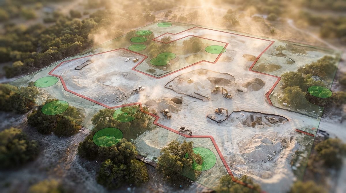
The process starts with the RTK drone survey, which maps the property in 3D, locates all trees by canopy position, and identifies every protected specimen by species and estimated trunk diameter. CRZ boundaries are calculated digitally and overlaid on the site plan before any clearing begins. Arborist coordination happens at this stage — not after something goes wrong.

The clearing crew then works the site with those boundaries physically flagged on the ground, cross-referenced against the digital model in real time. The post-clear RTK scan documents every protected tree's final condition as evidence for city review.

Pre-clear RTK canopy survey — every tree on the property identified, measured, and mapped in 3D before clearing begins
CRZ calculation and digital boundary mapping — protected zones computed to ordinance spec, overlaid on DroneDeploy site model
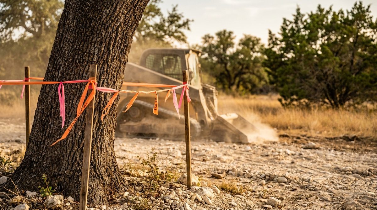
Physical CRZ flagging on-site — boundaries marked on the ground before the first machine pass, cross-referenced to the digital plan
Arborist coordination — arranged when permit or city review requires a certified arborist assessment; passed through at cost
Selective clearing of all non-protected vegetation — brush, cedar, invasive species, non-protected trees, and understory removed to spec
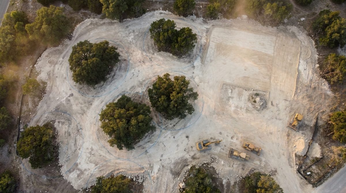
Post-clear RTK documentation — final condition of every protected tree documented; digital twin and photo record delivered for city review
Standard Clearing Approach
Walk the lot, flag a few trees, start clearing
CRZ boundaries guessed from trunk position
Protected tree discovered after equipment moves nearby
No documentation — city arborist takes your word for it
Violation discovered at permit review stage
Arborist called in reactively — mitigation process begins
VS
ClearGround Selective Clearing
RTK drone survey maps every tree before mobilization
CRZ calculated to ordinance spec, overlaid digitally
Boundaries physically flagged on-site before clearing starts
Pre/post RTK documentation package ready for city review
Compliance built in — not checked at the end
Arborist coordinated proactively when required
Pricing
Selective clearing pricing is driven by tree count and CRZ complexity, not just lot size. A single heritage live oak on the edge of the clearing zone is a straightforward boundary flag. Four trees with overlapping CRZs across the construction footprint requires a precision plan, slow-speed machine work, and arborist coordination. The pre-clear scan determines which situation you're in before the quote is final.
SC.01

Pre-Clear Heritage
Tree Survey

Before any machine moves, the DJI Mavic 3 RTK flies the full property and builds a 3D canopy model. Every tree is located, species is assessed, and trunk diameter is estimated from the aerial data — flagging all potential protected specimens for ground-truth verification. The survey is what turns an assumption into a documented plan. This is the step that tells you how many protected trees you actually have, where their CRZs fall relative to your clearing zone, and whether any of them are going to require an arborist before clearing begins.

DJI Mavic 3 RTK · DroneDeploy Processing
3D Canopy Map + Ground-Truth Walk
Protected Tree Count + CRZ Overlay
Output: Site Map + CRZ Boundary File
$400 – $900
Per site. Included in full selective clearing scope — quoted separately when survey-only is needed.
What drives the price up: Property size is the main variable — a standard 50×100 infill lot takes one drone flight, while a multi-acre Hill Country site requires multiple flight patterns and more processing time. Dense canopy coverage slows species identification. Sites with many trees near the size threshold require a careful ground-truth walk to confirm which specimens clear the ordinance size cutoff. When the survey is a standalone deliverable (for a client who wants to know what they're dealing with before committing to a project), it's quoted independently. When it rolls into the full selective clearing project, it's bundled into the overall scope pricing.
[RTK Survey Canopy Map] DroneDeploy interface showing aerial canopy map of Austin lot with CRZ boundaries
Illustrative — representative visualization
SC.02

CRZ Flagging +
Boundary Management

CRZ boundaries calculated from the survey data are physically staked and flagged on the ground before clearing begins. The physical boundary is cross-referenced to the digital site plan in real time — the operator has both the flag in front of them and the DroneDeploy model on the tablet. There's no relying on memory or a hand-drawn sketch. If the machine gets near a flagged boundary, the operator has two independent references telling them where the line is. That redundancy is what makes city arborist sign-off straightforward rather than contested.

Physical CRZ Staking + High-Visibility Flagging
Digital Boundary Cross-Reference (DroneDeploy)
Real-Time Plan Available to Operator
Post-Clear Boundary Confirmation Photo Set
Included
CRZ flagging is standard on all selective clearing projects. Not an add-on.
What affects this scope: Tree density and CRZ overlap drive complexity. A single isolated heritage oak with clear open space around it takes 20 minutes to flag. A cluster of three overlapping CRZs that bisects the clearing zone requires more precise staking, additional visual markers for the operator, and a pre-work walkthrough with the machine operator to confirm the plan before the first pass. Multi-acre properties with many protected trees may require updated flagging mid-project if clearing stages move across the property in phases.
[CRZ Flagging Photo] Orange or pink CRZ boundary flagging visible around a heritage live oak. ClearGround
SC.03

Selective Clearing
& Vegetation Removal

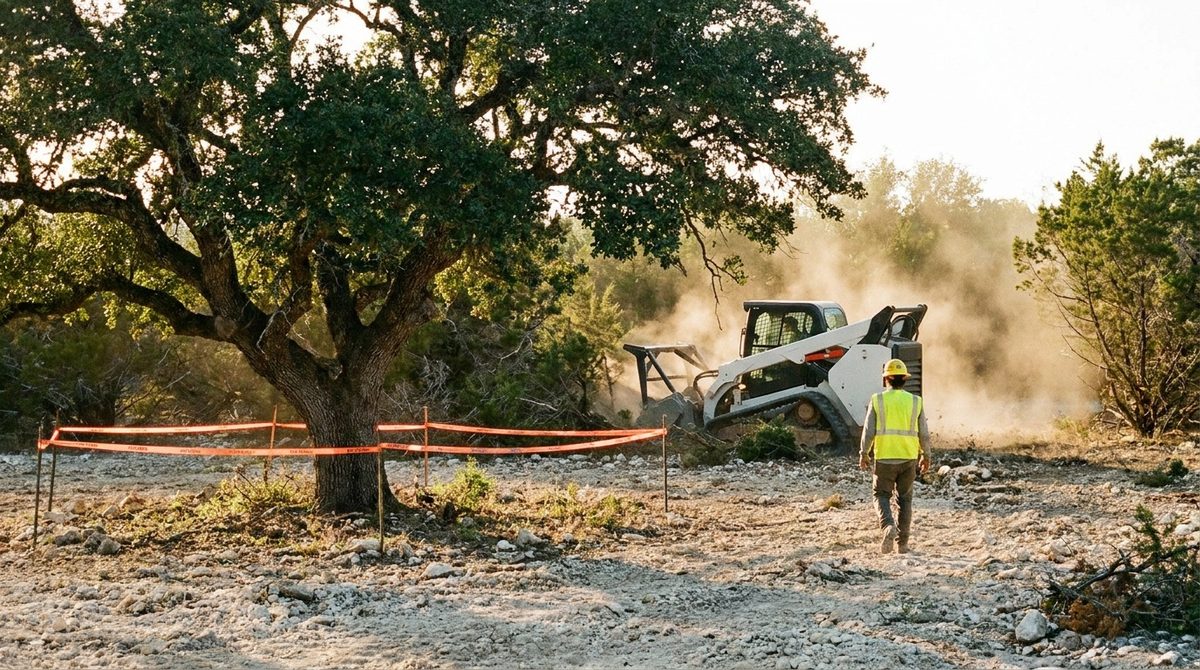
With boundaries flagged and the plan confirmed, clearing begins — targeting all non-protected vegetation while routing the machine around every marked CRZ. Cedar, brush, invasive species, non-protected trees, and undergrowth are processed with the FAE mulching head and mulched in place or stockpiled. Protected trees are not approached within their flagged boundaries. If clearing requires work near a CRZ, the operator slows, references the digital plan, and works by hand or with a smaller attachment if necessary. The machine stops before the line gets crossed.

CAT 299D3 XE + FAE Mulching Head
CAT 308E2 CR (precision near-CRZ work)
Non-Protected Trees, Cedar, Brush, Invasive Species
Mulched In-Place or Stockpiled for Removal
$3,500 – $9,000
Per site. Lot size and vegetation density are primary variables. Heritage tree count affects planning time but not necessarily the clearing cost itself.
What drives the price up: Dense vegetation that's hard to process through the mulching head takes longer per square foot. Properties with multiple overlapping CRZs that divide the clearing zone into smaller sections require more machine repositioning and slower passes — you can't make long straight runs when boundaries cut across the clearing area. Trees with large canopy spread that overhangs into the clearing zone require careful work to avoid disturbing branches connected to the root system. If the project requires debris removal rather than mulching in place, haul-off adds $30–$50 per cubic yard.
[Selective Clearing Mid-Work Photo] CAT 299D3 XE clearing non-protected vegetation. Heritage live oak with CRZ flagging
SC.04

Arborist Coordination +
City Documentation

Some Austin permits require a certified arborist's written assessment before clearing is approved. Others require documentation after the fact to confirm no protected trees were damaged. Either way, the documentation package matters — because what the city arborist reviews isn't a description of the work. It's the before/after RTK record that proves it. ClearGround produces the pre-clear survey data, post-clear condition documentation, and CRZ boundary compliance record. Arborist coordination is arranged at cost when the permit requires it; the arborist uses our scan data to prepare their own assessment.

Pre-Clear RTK Canopy Survey + CRZ Map
Post-Clear Condition Documentation (Photo + RTK)
Digital Twin Delivered via DroneDeploy
Arborist Coordination — arranged at cost when required
$600 – $1,800
Documentation package per protected tree or site. Arborist assessment fees passed through at cost ($150–$400 per tree).
What drives the price up: Tree count is the primary variable — each protected tree gets its own pre/post RTK documentation record and CRZ compliance confirmation. Sites with trees close to the clearing zone require more detailed post-work photography and additional measurements to demonstrate no root zone disturbance occurred. Arborist fees vary by firm and tree count — ClearGround passes these through at cost with no markup. If the city arborist's review triggers a follow-up inspection or questions about specific tree condition, ClearGround provides the digital documentation to support the response without additional charge.
[Documentation Package Photo] DroneDeploy 3D interface showing post-clear orthomosaic of Austin lot. Heritage trees visible with
Illustrative — representative visualization
Included in Every Selective Clearing Project

Pre-clear RTK drone survey, CRZ digital boundary mapping, physical on-site flagging, selective clearing to spec, post-clear RTK condition documentation, and digital twin delivered within 48 hours. The documentation that gets your city review through the first time is standard — not an add-on you have to request.

The Critical Root Zone

Understanding the CRZ.
What you can't touch and why.

The Critical Root Zone is the circular ground area around a heritage tree within which soil disturbance can damage or kill the root system — even if the tree itself isn't touched. The ordinance defines it mathematically: one foot of radius for every inch of trunk diameter at breast height.

A 24-inch live oak has a 24-foot CRZ radius. That's a circle of protected ground 48 feet across. On a tight infill lot where the clearing zone overlaps that circle, the machine operator needs to know exactly where the line is — not approximately, not from a sketch on a clipboard.

The RTK survey establishes the boundary to centimeter accuracy. The digital overlay shows the operator in real time which ground they can work and which they cannot. That's what makes the difference between clearing that completes on schedule and clearing that stops when the city arborist arrives.

Soil compaction inside the CRZ is also a violation — even without cutting or scraping. That means no equipment parking, no material stockpiling, no site trailer placement inside the zone. The protection follows the tree everywhere.

What a Violation Costs

Austin calculates heritage tree violation penalties by tree size and species value. A 24" live oak violation can trigger $15,000–$30,000 in mitigation payments — before arborist assessment fees, permit hold costs, and schedule delay losses are factored in. On an infill pro forma, that single line item can eliminate the project margin entirely.

CRZ Calculation Reference
Formula CRZ Radius = Trunk Diameter (inches) × 1 ft
19" DBH live oak 19 ft radius / 38 ft diameter
24" DBH live oak 24 ft radius / 48 ft diameter
30" DBH live oak 30 ft radius / 60 ft diameter
36" DBH post oak 36 ft radius / 72 ft diameter
20" DBH cedar elm 20 ft radius / 40 ft diameter
Protection threshold: generally 19" DBH for most protected species. Confirm with city arborist for multi-trunk specimens and edge cases. CRZ radii above are approximate — ordinance formula governs.
How It Works

Five steps from raw site
to city-ready documentation.

The sequence exists because every step sets up the one after it. The survey locates the trees. The CRZ calculation defines the boundaries. The flagging puts those boundaries on the ground. The clearing works within them. The post-clear scan proves they were honored. Skipping or reordering any step breaks the compliance chain.

Timeline: A typical selective clearing project on an Austin infill lot (1–4 protected trees, 0.25–0.5 acres of clearing) runs 1–2 days. Multi-acre Hill Country properties with more protected trees and more complex CRZ layouts run 3–4 days. The survey and documentation phases happen before and after clearing — they don't extend the on-site work window.
Phase 01
RTK Canopy Survey
DJI Mavic 3 RTK flies the full property. 3D canopy model built. All trees located, species assessed, trunk diameters estimated. Protected specimens identified for ground-truth verification. Pre-clear condition documented.
DroneDeploy · ±0.5cm
Phase 02
CRZ Calculation + Digital Boundary
Protected tree CRZs calculated to ordinance spec from survey measurements. Boundaries overlaid digitally on the DroneDeploy site plan. Clearing zone defined precisely around each protected area. Plan reviewed before any mobilization.
Ordinance Compliance · Boundary File
Phase 03
Physical Flagging + Arborist
CRZ boundaries physically staked and flagged on the ground from the digital plan. Machine operator walks boundaries before clearing begins. Arborist assessment arranged at this stage if the permit requires it.
On-Site Flagging · Arborist Coordination
Phase 04
Selective Clearing
All non-protected vegetation removed — cedar, brush, invasive species, non-protected trees, and understory. Machine routed around every flagged CRZ. Vegetation mulched in place or stockpiled. Protected trees untouched.
CAT 299D3 XE + CAT 308E2 CR
Phase 05
Post-Clear Documentation
Drone flies again. Post-clear orthomosaic and 3D model confirm all protected trees standing with CRZs undisturbed. Before/after record compiled. Digital twin and documentation package delivered within 48 hours for city review.
As-Built Twin · 48hr Delivery
The ClearGround Difference

Compliance is built into
the plan. Not
checked at the end.

Most clearing contractors handle heritage tree compliance the same way: mark a few trees, tell the operator to stay away from them, and hope the city doesn't look closely. That works until it doesn't — and when it doesn't, the liability lands on the developer, the builder, and the property owner simultaneously.

ClearGround builds the survey, the CRZ calculation, and the documentation into the project workflow because the documentation is what makes the compliance verifiable. The city arborist doesn't take your word that you stayed out of the root zone. They look at the before/after record. We produce that record as a standard deliverable on every project.

Scan Before Clearing
RTK drone survey before any machine moves. Every tree located, every CRZ calculated from data — not from a tape measure and a guess in the field.
Dual Verification
Physical flagging plus digital plan in the operator's hand. Two independent references for every CRZ boundary. Neither system relies on memory.
Arborist-Ready Data
The documentation package is built for city review from day one. The arborist who reviews your project gets georeferenced orthomosaics and RTK condition data — not field photos and a written description.
Permanent Record
The 3D digital twin is a permanent, measurable record of the site condition before and after clearing. If a question arises years later about tree damage from the clearing work, the data exists to answer it.
Who This Is For

Anyone building where
protected trees are standing.

Pool & Estate Builders

Westlake · Lakeway · Tarrytown · Rollingwood · Spicewood

Hill Country lots in the high-value Austin corridors are almost always populated with live oaks — and almost all of those oaks trigger heritage tree protection. When your client's pool site has a 24-inch live oak 30 feet from the proposed shell, the CRZ is 48 feet in diameter. That circle may overlap your excavation zone, your equipment staging area, and your access path. ClearGround maps those constraints before your crew mobilizes so the dig starts on a cleared lot with documented compliance — not a liability.

Common scenario
"The lot has a heritage oak right in the middle of where we need to clear for pool access. We need everything around it gone but we can't touch the tree. And we need the documentation to show the city we didn't."
How we work with pool builders

Infill Developers

East Austin · Hyde Park · Bouldin · Cherrywood · Clarksville

Austin's infill corridors — the HOME initiative lots, the Carr ADU sites, the East Austin tear-down-and-rebuilds — frequently have protected trees in positions that directly conflict with the clearing needed for demolition staging and foundation work. A heritage violation on a 50×100 lot doesn't just stop the clearing. It stops the whole project. ClearGround handles the compliance layer as part of the clearing scope so your GC picks up a foundation-ready lot with the documentation that city review needs already in hand.

Common scenario
"There's a live oak in the backyard that the city flagged on the survey. We need to clear for the ADU footprint without getting within 20 feet of it and we need to prove we did it right."
How we work with developers
Arborist Coordination

When the permit
requires an arborist.
Here's how that works.

Some Austin development permits require a certified arborist's written assessment before clearing is approved — particularly on lots near sensitive areas, on properties with multiple heritage trees, or when a prior permit had tree-related conditions attached. ClearGround doesn't provide arborist certification services, but we coordinate with certified arborists and produce the RTK data their assessment is based on. The arborist uses our pre-clear canopy survey and CRZ boundary map to prepare their written assessment — it's faster, more accurate, and more defensible than an arborist doing a standalone site walk without the 3D baseline.

What We Provide
Pre-clear RTK canopy survey, species identification notes, estimated DBH measurements, CRZ boundary file, and digital twin. This is the data set the arborist works from for their written assessment.
What the Arborist Does
Provides the certified written assessment required by the permit. Reviews our data, conducts their own site walk if required, and submits their professional opinion to the city. Their fee is separate and passed through at cost — typically $150–$400 per tree.
Why It Works Better
An arborist working from a georeferenced 3D canopy model can prepare their assessment faster and with more precision than from field notes alone. The city reviewer gets a cleaner submission. The process moves faster.
When It's Not Required
Many selective clearing projects don't require a formal arborist permit. ClearGround's RTK documentation package is sufficient for city review when clearing doesn't trigger a permit condition. The pre-clear scan identifies what the permit situation is before you're committed to the project scope.
Common Questions

What people ask before
they book the scan.

The protection is based on species and trunk diameter. Most protected species (live oak, post oak, cedar elm, Texas live oak, and others listed in the Austin Land Development Code) trigger heritage protection at 19" DBH — diameter at breast height, measured at 4.5 feet above grade. Multi-trunk trees are measured using a formula based on the aggregate of the trunks. The pre-clear RTK survey identifies all trees on the property and flags any specimen that is close to or above the size threshold for ground-truth measurement. If you're not sure whether a tree qualifies, the answer is to measure it before clearing begins — not after.
The most common violation isn't cutting a protected tree down — it's encroaching on the CRZ during clearing, grading, or equipment staging. A machine that compacts soil inside the root zone can damage the tree without touching it. A clearing crew that scrapes within the CRZ while removing brush near the base triggers the ordinance. The city can issue a violation based on post-work inspection by an arborist who observes soil disturbance, root exposure, or bark damage within the protected zone. The stop-work order applies to the full project — not just the clearing phase. And the mitigation payment is calculated by the city, not negotiated.
Not always. Many selective clearing projects — particularly those where the clearing zone doesn't directly conflict with a protected tree's CRZ — can proceed with RTK documentation alone, without a formal arborist assessment. The pre-clear survey establishes whether you're in a situation that requires a certified arborist permit or whether ClearGround's documentation package covers the city review. When an arborist is required, we coordinate it — we don't leave that step to the property owner to figure out independently. Arborist fees are passed through at cost with no markup.
The ordinance defines the CRZ as the protected zone — work outside it is permitted, work inside it is not. In practice, ClearGround operates with a small working buffer inside the flagged boundary to account for machine width, operator precision, and ground conditions. The machine does not work at the theoretical CRZ line. It works to a safe operating distance from it. How close depends on the situation — dense brush right at the CRZ boundary requires slower, more careful work than open ground. The post-clear RTK scan confirms where the machine actually worked relative to the boundary.
This is the situation where the pre-clear survey earns its keep. If the tree's CRZ overlaps the clearing zone significantly enough that standard machine work isn't possible within the boundary, there are a few options: hand clearing within the CRZ-adjacent zone (slower, more expensive, but possible), a modified project footprint that routes around the constraint, or coordination with the city arborist to explore whether a variance applies. We surface that constraint before mobilizing — not after the machine is on-site. A clearing plan that can't be executed as designed is a problem we find in the survey phase, where adjustments cost nothing, not in the field, where they cost everything.
The RTK digital twin is a permanent, georeferenced record that doesn't degrade or lose precision over time. The DroneDeploy model is stored in the cloud and accessible indefinitely. If a city arborist, a permit reviewer, or a future property owner has questions about the state of the trees before and after clearing, the data is there to answer them. This is one of the practical reasons the 3D documentation matters beyond just getting through the initial review — it's a defensible record of what happened, measured to centimeter accuracy, with timestamps. Field photos and a written narrative are not.
Ready to start

Know what you're
working with before you clear.

Book a free RTK site scan. We'll map every tree, calculate every CRZ, and tell you exactly what your selective clearing plan looks like before a machine gets near the property.

Book Your Site Scan