TX contractor LIC
UT contractor INS
FAA PART 107 FAA 107
Insurance $2M GL
Technology About Contact
Texas Hill Country fire season is year-round · FFSL-documented defensible space is your insurance evidence · Cedar removal is the single highest-impact fuel reduction available
ClearGround Forestry Mulching Wildfire Mitigation
Forestry Mulching — Wildfire Mitigation

Is your Hill Country estate a fire hazard? Most are. We'll show you in 3D — and fix it in one pass.

Wildfire Mitigation
& Defensible
Space

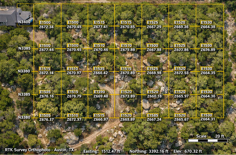
Cedar and dry brush aren't just a view problem — they're a fuel load. Texas Hill Country estates routinely sit inside land that would carry a fire at 60+ mph with zero natural firebreaks. We create documented, drone-verified defensible space around your structures using a single machine pass. No hauling. No burning. FFSL-standard clearance zones verified to ±0.5cm.

30–100ft
FFSL Zone 1 Requirement
±0.5cm
RTK Accuracy
1
Pass. No Hauling.
Zero
Burn Permits
The Hill Country Fire Reality

Cedar Isn't Just Ugly.
It's a Fuse.

Ashe Juniper — what Texans call cedar — is the most effective wildfire accelerant in the Hill Country. A single mature cedar can hold 50+ gallons of volatile oil. Dense cedar stands carry ground fire into canopy fire in seconds, and canopy fire moves faster than most people can run. If your structure sits within 100 feet of an untreated cedar stand, you have a problem that a garden hose won't solve.

FFSL & Insurance Standards

The Texas A&M Forest Service (FFSL) recommends 30–100 feet of treated defensible space around all structures in the Texas Hill Country — with specific fuel reduction standards for each zone. Insurance carriers are increasingly requiring documented defensible space compliance for properties in Gillespie, Kerr, Kendall, Blanco, Llano, and Travis counties as a condition of coverage or renewal.

ClearGround's RTK drone verification produces documentation that meets FFSL defensible space standards and is formatted for insurance carrier submission. You get proof — not a verbal assurance.

FFSL Defensible Space Standards NFPA 1144 Zone Framework Insurance-Ready Documentation Before / After 3D Verification Kerr · Gillespie · Kendall · Blanco · Llano Counties
Why Cedar is Different

The Volatile Oil Problem

Ashe Juniper produces aromatic oils throughout its wood, bark, and berries that ignite at lower temperatures and burn significantly hotter than most other Texas species. Dead cedar — the silver skeleton trunks common in drought-stressed stands — is effectively kiln-dried fuel. A 10-acre cedar monoculture is a fuel load that professional firefighters won't enter.

The same properties that look picturesque with cedar silhouettes against limestone ridges are, from a fire behavior standpoint, maximally dangerous terrain. The view problem and the fire problem have the same solution: removal.

Cedar ignition temperature vs. live oak 40% Lower
Canopy fire speed in dense cedar 60+ mph
Volatile oil content vs. average hardwood 3–5× Higher
Ground-to-canopy fire transition time < 30 seconds
After Treatment

What Defensible Space Actually Does

Properly treated defensible space does three things. First, it eliminates the fuel pathway from wildland fire to your structure — a fire that hits a cleared zone typically stalls or drops to ground level where suppression is possible. Second, it reduces ember landing zones around your structure — most structure ignitions in wildland-urban interface fires start from ember landing on debris, decks, or landscaping, not from direct flame contact.

Third — and most underestimated — it gives firefighters a safe working perimeter. A structure with clear defensible space is defensible. A structure surrounded by cedar is not. This affects every emergency response decision made when a fire approaches your property.

Structure survival rate with 30+ ft clearance Dramatically Higher
Ember landing zone reduction Significant
Emergency responder access Restored
Insurance compliance documentation Drone-Verified
FFSL Zone Framework

Three Zones.
One Clearing Plan.

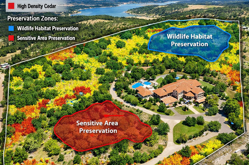
FFSL defensible space guidelines define three treatment zones around structures, each with different clearing standards. Your site scan maps all three zones on your actual terrain — accounting for slope, wind exposure, and existing vegetation — before we quote a price or start a machine.

Zone 1 — Immediate
0–30 ft
Lean, Clean & Green

The highest-priority zone immediately around your structure. Vegetation in this zone ignites directly from structure heat and can carry fire directly to wood siding, decks, and eaves. This zone must be the most aggressively treated — and the most thoroughly documented.

Remove all dead vegetation, wood debris, and fallen branches
Eliminate continuous shrub coverage — no fuel pathways to structure
All trees limbed up 6–10 feet from ground to break ladder fuels
Deck, roof, and gutter areas clear of leaf and needle accumulation
RTK-verified clearance distances from structure documented
Zone 2 — Reduced Fuel
30–100 ft
Scattered & Thinned

The zone where fire can gain momentum before reaching Zone 1. Vegetation here doesn't need to be eliminated — but it needs to be thinned to break the continuous fuel pathway. Dense cedar stands in Zone 2 carry the same fire behavior as Zone 1 — this zone must be treated seriously.

Cedar and juniper thinned to break continuous canopy
Single-species stands broken up — no ladder fuels connecting ground to canopy
Spacing between remaining shrubs: 2× height on slopes, 3× on flat
Dead material removed throughout — no standing dead cedar
RTK density measurements confirm reduction meets FFSL spec
Zone 3 — Extended Buffer
100–200 ft
Reduced Fire Behavior

The outer buffer zone where fire behavior can be slowed before reaching your treated inner zones. FFSL guidelines for this zone focus on eliminating the most hazardous fuel types and reducing continuous fire pathways, particularly on slopes where fire accelerates uphill. This zone is especially important for properties on ridgelines or with south/west exposure.

Eliminate dense cedar monocultures that carry fast-moving fire
Reduce slope-aligned fuel corridors that accelerate fire uphill
Access roads cleared for emergency responder ingress
Strategic firebreaks coordinated with terrain and prevailing wind
High-Risk Fuel Species
Ashe Juniper (Cedar) Honey Mesquite Live Oak Deadwood Dry Grasses / Thatch Prickly Pear (Dense) Standing Dead Cedar Shin Oak — Selective Agarita — Selective Live Oak — Canopy Preserved Native Grasses — Preserved Specimen Oaks — Limbed & Preserved
What We Do

Wildfire Mitigation
Services

From single-structure defensible space to whole-property fire risk reduction, every service is built on the same RTK drone baseline and delivers verified documentation as the final deliverable.

Core Service
Defensible Space Creation

Full three-zone defensible space treatment around structures — drone-mapped, machine-cleared, and RTK-verified. We create Zone 1, Zone 2, and Zone 3 clearance per FFSL guidelines and document every cleared distance to ±0.5cm. The before/after Digital Twin is your insurance evidence package.

Duration: 1–5 days · Equipment: CAT 299D3 XE + FAE Head + Mavic 3 RTK
$3,000 – $4,500
/ acre

5–50 acre properties. Pre-clearing RTK scan included.

What drives the price up

Properties with structures require more precise clearing planning — defensible space zones, ember-resistant perimeters, and access road clearance must all be coordinated. Steep terrain limits machine speed and adds time per acre. Dense cedar mixed with live oak requiring selective preservation takes longer than uniform cedar stands.

Fire Behavior Control
Strategic Firebreak Creation

Terrain-mapped firebreaks that disrupt fire pathways on your property — coordinated with ridge lines, slope aspects, and prevailing wind direction. We identify where fire will run fastest on your specific terrain and place breaks where they'll intercept it, not just where they're easiest to cut.

Duration: 1–3 days · Equipment: CAT 299D3 XE + FAE Head + Mavic 3 RTK
$2,500 – $6,000
/ mile

Linear pricing per cleared mile. Terrain analysis included.

What drives the price up

Firebreaks on steep rocky terrain require slower machine speeds and more repositioning than flat corridor cuts. Breaks that must integrate with existing fence lines or water features require additional planning. Topographic complexity — ravines, ridgelines, and drainage crossings — adds coordination time per linear mile.

Infrastructure
Emergency Access Road Clearing

Overgrown ranch and estate roads aren't just inconvenient — they're life safety issues. A fire apparatus needs 12–14 feet of unobstructed width and overhead clearance to 14 feet. We clear existing roads to emergency access standards and document the clearance with RTK measurements. Your road is now part of your defensible space evidence package.

Duration: 0.5–2 days · Equipment: CAT 299D3 XE + FAE Head
$2,500 – $5,000
/ mile

Min. 0.25 mile. Clearance measured and documented.

What drives the price up

Roads with heavy overhead canopy requiring vertical clearance as well as horizontal width take more time per mile. Existing road surface damage from roots or erosion may require concurrent grading. Drainage crossings and switchbacks add maneuvering time. Roads that haven't been maintained in 5+ years typically have encroaching cedar at grade level that requires additional passes.

Infrastructure
Post-Fire
Wildfire Recovery & Rehabilitation

If your property has already experienced a fire, the recovery work is as important as the prevention. Burned cedar and dead standing material represent a secondary fire hazard and a structural risk. We clear and process post-fire debris in place, document the recovery scope with RTK drone data, and provide the before/after evidence your insurance adjuster needs.

Duration: 3–10 days · Equipment: CAT 299D3 XE + FAE Head + Mavic 3 RTK
$3,000 – $4,500
/ acre

5–50 acre recovery areas. Insurance documentation included.

What drives the price up

Post-fire debris varies significantly in density and type. Properties with significant limestone exposure may require integrated rock milling for access. Structural debris mixed with vegetative debris requires careful separation and processing. RTK drone mapping of a burned property requires additional flight planning to account for altered terrain features.

Assessment Only
RTK Fire Risk Site Assessment

Not ready to clear but need to know where you stand? Our standalone fire risk assessment maps your entire property with RTK drone data — identifying Zone 1, Zone 2, and Zone 3 fuel loads, flagging the highest-risk areas, and producing a 3D Digital Twin with a defensible space action plan. Take it to your insurance carrier or use it to prioritize your clearing budget.

Duration: Half day · Equipment: Mavic 3 Enterprise RTK
$1,000 – $2,500
flat rate

Up to 50 acres. Includes 3D model + risk report.

What drives the price up

Larger properties require more flight time and more data processing. Properties with significant slope variation require terrain-following flight planning. Reports formatted specifically for insurance carrier submission require additional documentation time. Rush turnaround requests (under 24 hours) carry a premium.

Multi-Property
HOA & Community Fire Mitigation

Hill Country communities and HOAs with shared fire risk need a coordinated mitigation strategy — not 50 individual property owners each doing partial work that leaves gaps in the fuel reduction buffer. We assess and treat community-wide — shared easements, common areas, road corridors, and the zone of concern beyond individual lot lines.

Duration: 3–10 days · Equipment: Full Stack
Contact Us
community pricing

HOA / community assessments from first contact.

What drives the price up

Community projects scope varies enormously — from 10-lot HOAs to 200-lot ranch communities with miles of shared access roads. We scope every community project from an initial aerial survey before quoting. Volume pricing applies to multi-lot projects and results in per-acre costs meaningfully lower than individual property pricing.

Included in Every Clearing Service
Pre-Clearing RTK Drone Scan
FFSL Zone Mapping
Post-Clearing Verification Scan
Before / After Digital Twin
Insurance Evidence Package
Veteran Operator + All Fuel
Zero Burn Permits
Zero Hauling Fees
See It In Action

Drone Scan.
3D Risk Map.
One Pass.

Before any machine rolls, you see your fire risk in 3D. Fuel loads mapped by zone. Clearing plan built from the data. No guessing about what the property looks like from 400 feet.

Job Site Video — Defensible Space Creation
Video coming soon — Job Site Video — Defensible Space Creation
Most Clearing Crews Don't Document Clearance Distances

At Any Phase of Your
Wildfire MitigationSee the Data

Phase 01
Pre-Clearing Fire Risk Survey

We Map the Threat Before We Clear It.

Before the machine rolls, a Mavic 3 Enterprise RTK drone flies your entire property — mapping vegetation density by zone, identifying the highest-risk fuel concentrations, flagging slope aspects that accelerate fire uphill, and marking every structure setback that defines your defensible space zones.

The resulting 3D model shows your Zone 1, Zone 2, and Zone 3 fuel loads on your actual terrain. You see exactly where the risk is concentrated, which structures are most exposed, and what the clearing plan will look like before we quote a price. This isn't a clipboard survey — it's survey-grade data.

±0.5cm RTK Accuracy FFSL Zone Mapping Cedar Density by Zone Slope / Wind Exposure Analysis Structure Setback Measurement
FULL PROPERTY MAPPED · RISK ZONES QUANTIFIED · PLAN APPROVED
Phase 02
Precision Clearing Execution

One Pass. Every Zone Treated.

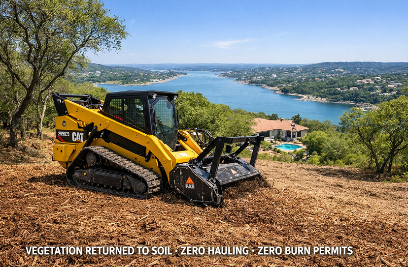
Our CAT 299D3 XE with FAE mulching head works the property systematically — Zone 1 first, then Zone 2, then Zone 3 and access road corridors — following the approved clearing plan from Phase 01. Cedar and juniper are ground in place at chip level. No flame. No hauling. No burn permits. The mulch layer that remains actually reduces the fine-fuel fire risk at ground level while protecting your soil.

Specimen live oaks and other desirable trees are preserved exactly as marked in the plan. Structure setbacks, firebreak lines, and zone boundaries are maintained with RTK reference data on the machine operator's display throughout the job.

CAT 299D3 XE FAE Mulching Head Zone-by-Zone Sequence Zero Burn Permits Zero Hauling RTK Boundary Reference
Phase 03
Mid-Job Zone Verification

Every Zone Distance Checked In Real Time.

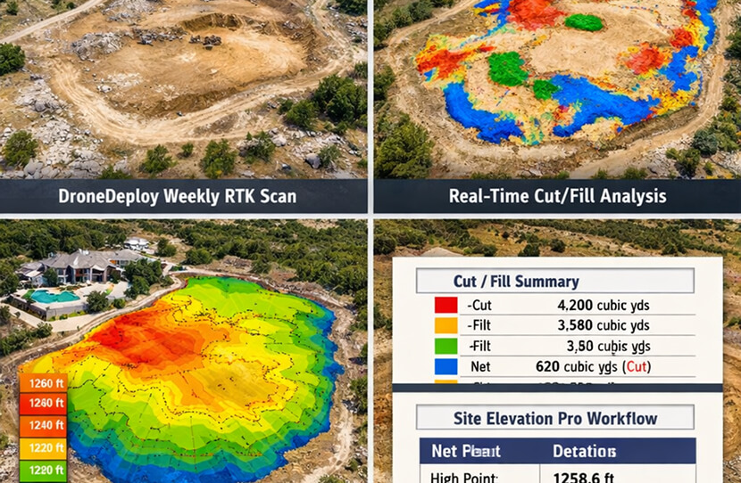
On multi-day projects, we fly mid-job drone scans to verify clearance distances are hitting FFSL spec — did Zone 1 reach the required 30-foot setback? Is Zone 2 thinned to the density standard? Is the access road corridor fully cleared to emergency vehicle width? The data answers objectively. If something's off, we know about it before the machine moves to the next zone.

You have access to this progress data without having to drive out to the property. The drone shows you exactly where the crew is and what they've cleared, updated as the job progresses.

Mid-Job RTK Scans FFSL Clearance Verification Zone Boundary Confirmation Real-Time Progress Sharing
CLEARANCE DISTANCES VERIFIED · ZERO SURPRISES AT INVOICE TIME
Phase 04
Completion & Compliance Verification

Before & After. ±0.5cm. Every Zone Documented.

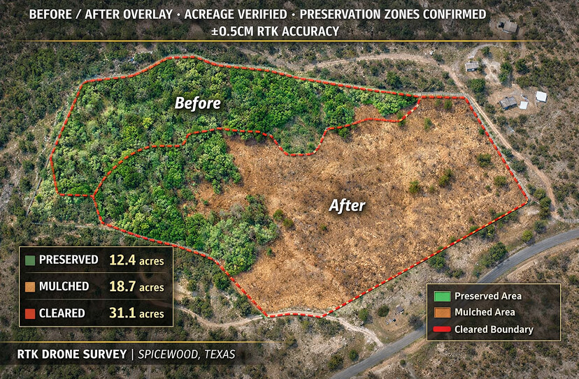
Final RTK drone survey maps the completed defensible space to the same survey-grade accuracy as the baseline. We overlay it against the pre-clearing scan so you see exactly what changed — zone by zone, meter by meter. Every clearance distance is measured and recorded. Every preserved tree is confirmed. The before/after comparison is your documented proof of compliance.

If any zone didn't hit spec — for any reason — it gets addressed before we leave the property. The final documentation only goes out when the work matches the plan.

Before / After Overlay FFSL Zone Measurements Clearance Distance Records Preserved Tree Confirmation ±0.5cm RTK Accuracy
Phase 05
Compliance Deliverable

Your Insurance Package.
Your Permanent Record.

You receive a complete compliance package: an interactive 3D Digital Twin of your property before and after clearing, hosted on Pix4D Cloud with a shareable link. A before/after comparison report with FFSL zone measurements. A timestamped RTK evidence package formatted for insurance carrier submission. And a branded compliance documentation report for your records, your HOA, and your fire department.

No other clearing company in Central Texas delivers this package. Most hand you an invoice and a handshake. We hand you documented proof that your property was treated to standard — proof that stands up when fire season arrives and your insurance carrier asks for evidence.

3D Digital Twin — Shareable Link FFSL Zone Compliance Report Insurance Evidence Package Before / After Archive Annual Maintenance Baseline
INSURANCE-READY · MUNICIPALITY-READY · PERMANENTLY ON RECORD
Wildfire doesn't wait for a slow quote process.

Free RTK Site Scan for
Qualifying Properties.

We're selectively offering complimentary RTK site scans for wildfire mitigation projects in Austin and the Texas Hill Country. No obligation. You get a 3D model of your property showing FFSL zone fuel loads before we quote a price. If you want to proceed, we'll talk numbers backed by data.

Book Your Site Scan
From the Field

Real Projects.
Austin & Hill Country.

Every photo is from a real ClearGround job site. No stock. No renders. What you see is what we do.

Transparent Pricing

Wildfire Mitigation
Pricing — Central Texas

Fire mitigation pricing varies with terrain and fuel density — but your quote should never be a mystery. Every price below reflects real project costs in the Austin and Hill Country market. Your site scan tells us which range applies to your property before we quote a number.

Service Duration Scope 2026 Range
Zone 1 Defensible Space (0–30 ft) Half–1 day Per structure $3,000 – $6,000 / structure
Full Three-Zone Defensible Space 1–5 days 5–50 acres $3,000 – $4,500 / acre
Strategic Firebreak — Moderate Terrain 1–2 days Per linear mile $2,000 – $3,500 / mile
Strategic Firebreak — Rocky / Steep 2–4 days Per linear mile $3,500 – $5,000 / mile
Emergency Access Road Clearing 0.5–2 days Per linear mile $2,500 – $5,000 / mile
RTK Fire Risk Site Assessment Only Half day Up to 50 acres $1,000 – $2,500 flat
Wildfire Recovery / Post-Fire Rehab 3–10 days 5–50 acres $2,000 – $4,000 / acre
HOA / Community Fire Mitigation 3–14 days Multi-property Volume pricing — contact us

All clearing services include veteran operators (12–20 years experience) and all fuel/maintenance costs. Highlighted rows are core defensible space services. Properties with significant limestone outcroppings may require integrated rock milling. Insurance evidence packages are included in all clearing services at no additional charge.

Pre-Clearing RTK Scan
FFSL Zone Documentation
Post-Clearing Verification
3D Digital Twin
Insurance Evidence Package
Zero Burn Permits
Recurring Maintenance

Defensible Space
Maintenance Plans

Defensible space isn't a one-time project. Cedar regrows. Dry grass accumulates. Dead material builds up. An annual maintenance plan keeps your cleared zones in compliance, your insurance documentation current, and your investment from reverting in two fire seasons.

Tier 01
Structure
Zone 1 perimeter maintenance
$2,000 / year
Billed Annually
Coverage Zone 1 — 0–30 ft
Frequency 1× Annual
Scope Single structure perimeter
Scan Annual compliance check
Tier 03
Community
HOA / multi-property annual program
Contact us
Custom Annual Agreement
Coverage Multi-property / HOA
Frequency Scheduled per community
Scope Lots + common areas + roads
Scan Annual 3D model update

All maintenance visits are compared against your original post-clearing baseline scan. You see exactly how much fuel accumulation occurred and confirmation that it was addressed. Every maintenance visit updates your insurance evidence package — so your documentation is always current when fire season arrives.

Who This Is For

Wildfire Mitigation
Clients

We work best with property owners who understand that the documentation is as important as the clearing — and who need proof of compliance, not just a job well done.

Primary Client
Hill Country Estate & Ranchette Owners

"My insurance renewal came back with a wildfire surcharge. My neighbor's property caught fire last summer. I have cedar right up to the deck."

You own 10–200 acres in Kerr, Gillespie, Kendall, Blanco, or Llano County and the cedar situation has crossed the line from aesthetic problem to genuine liability. You need it fixed, documented, and done without a crew burning anything or hauling debris across your roads.

See the Estate Owner Page
Primary Client
Insurance-Driven Property Owners

"My carrier is requiring proof of defensible space. I don't know what format they need or what 'proof' actually means to an insurance adjuster."

Your insurance carrier has sent you a requirement for documented defensible space compliance — and you need documentation that actually satisfies their requirements, not a photo on your phone. Our RTK evidence package is formatted to insurance carrier standards with timestamped measurements, before/after comparison data, and a 3D model link.

Book a Site Scan
Secondary Client
HOAs & Hill Country Communities

"We're a 40-lot community on the edge of the WUI. Individual property owners are doing partial clearing but the shared areas and road corridors are still full of cedar."

Community fire risk doesn't respect lot lines. A 40-lot HOA with 38 cleared lots and 2 untreated lots still has a fire problem if the untreated lots are upwind. We work with HOA boards to develop community-wide clearing plans that treat shared areas, road corridors, and the zone beyond individual lot lines.

Book a Community Assessment
The ClearGround Difference

Why Property Owners
Choose ClearGround

Every brush crew will show up and cut. We're the only one that shows up with a drone first, maps your risk in 3D, and leaves you documented proof that your property meets defensible space standards.

01
RTK Fire Risk Map Before Any Clearing

We map your entire property to ±0.5cm accuracy — Zone 1, Zone 2, Zone 3, fuel load density, slope exposure — before the machine arrives. You see the risk in 3D and approve the clearing plan. No surprises about what's getting treated or why.

Survey-Grade Baseline
02
FFSL-Standard Zone Documentation

Every clearance distance is measured, recorded, and overlaid on your 3D model to FFSL defensible space zone specifications. Your documentation isn't a contractor's word — it's RTK-verified data formatted to the standards your insurance carrier and fire department accept.

Insurance-Ready
03
No Burning. No Hauling. No Permits.

Cedar is ground in place by the FAE mulching head — returned to soil as mulch at chip level. Zero burn permits. Zero dump trucks. Zero tipping fees. The mulch layer actually reduces fine-fuel fire risk at ground level while protecting your soil structure from erosion.

Zero-Waste Method
04
Before & After Insurance Evidence Package

Your deliverable includes a timestamped before/after RTK evidence package specifically formatted for insurance carrier submission — with vegetation density measurements, clearance distances, and a 3D model link that any adjuster can access from a web browser. No software required.

Compliance Documented
05
Live Oak & Specimen Tree Preservation

Every tree you want preserved is marked in the pre-clearing plan and confirmed in the post-clearing scan. You tell us what stays. The machine navigates around it. The documentation confirms it happened. No "I thought that one was marked" conversations after the fact.

Preservation Verified
06
Emergency Responder Access Clearing

Defensible space includes access. We clear your roads and driveways to emergency vehicle standards — 12+ feet wide, 14+ feet overhead — and document the clearance as part of your compliance package. A fire apparatus that can't reach your structure can't defend it.

Full Access Documented
07
Annual Maintenance with Scan Comparison

Every annual maintenance visit is compared against your original post-clearing baseline. You see exactly how much fuel accumulation occurred and confirmation it was addressed — and your insurance documentation gets updated. Your compliance evidence stays current as long as you maintain the plan.

Ongoing Compliance
08
3D Digital Twin — Permanent Property Record

Your before/after Digital Twin lives on Pix4D Cloud with a shareable link — permanently. Use it to show your insurance carrier, your HOA board, a prospective buyer, or a fire mitigation consultant exactly what was done on your property and when. No other clearing company in Central Texas delivers this.

Permanent Record
09
Veteran Operators. Hill Country Experience.

The person operating the machine has 12–20 years of experience in terrain exactly like yours — limestone outcroppings, cedar thickets, live oak groves, rough Hill Country grade changes. They know how to work close to a structure without putting vibration into the foundation. That experience is not replaceable with a lower price.

Operator Quality
FAQ

Wildfire Mitigation
Questions Answered

The most common questions from Hill Country estate owners and property managers about defensible space, documentation, and how our process works.

What does FFSL defensible space documentation actually require? +
The Texas A&M Forest Service (FFSL) defensible space guidelines specify three zones around structures with different fuel reduction standards for each. Zone 1 (0–30 feet) requires removal of all dead vegetation and elimination of continuous fuel pathways. Zone 2 (30–100 feet) requires thinning to break continuous canopy and removal of ladder fuels. Zone 3 (100–200 feet) focuses on eliminating the most hazardous fuel concentrations. Documentation means measured, verifiable proof that those standards were met — not a verbal assurance. Our RTK drone verification produces exactly that: timestamped measurement data, before/after comparison, and zone-by-zone compliance confirmation.
Will my insurance carrier accept ClearGround's documentation? +
Our evidence package is formatted to the documentation standards insurance adjusters require: timestamped RTK photography with GPS coordinates, vegetation density measurements by zone, clearance distance records, a before/after 3D model accessible via web browser link, and a formatted compliance report. Most insurance carriers that require defensible space documentation accept georeferenced drone evidence formatted to FFSL zone standards. We recommend confirming your specific carrier's requirements before your site scan — if they have a specific format requirement, we'll build the deliverable to it. If they just say "documented defensible space," our standard package exceeds what they're looking for.
Why is mulching better than burning for fire mitigation? +
Three reasons. First, burn restrictions in the Hill Country are frequently in effect during the highest-risk periods — a clearing project that depends on a burn permit can be stalled for weeks or months. Mulching requires no permits and can proceed any time conditions allow machine operation. Second, burning generates significant embers and smoke that create their own risk during operation and can escape containment in dry conditions — a controlled burn on a fire mitigation project that escapes is an expensive and dangerous outcome. Third — and this surprises people — chip-level mulch returned to the soil reduces the fine-fuel fire risk at ground level. Heavy, coarse mulch layer is not flammable the way fine dry grass and leaf litter are. The material is returned to the soil at a particle size that doesn't carry fire.
How do you handle live oaks and specimen trees in a defensible space clearing? +
Live oaks and other desirable trees are not removed — they're preserved and treated as fire mitigation assets. A mature live oak with a cleared understory and limbed-up canopy actually enhances defensible space: the tree provides shade that reduces dry grass accumulation beneath it, the canopy height breaks potential ladder fuels, and the root system stabilizes the soil against post-clearing erosion. In Zone 1, live oaks are typically preserved with the understory cleared beneath them and the lowest limbs raised to 6–10 feet to remove ladder fuels. In Zones 2 and 3, they're preserved as part of a thinned canopy that interrupts continuous fuel pathways. Every preserved tree is marked in the pre-clearing plan and confirmed in the post-clearing scan.
How long does a typical defensible space project take? +
The pre-clearing RTK site scan is typically a half-day operation for properties up to 50 acres. The clearing itself depends on property size, fuel density, and terrain — a 5-acre Zone 1/2 treatment around a single structure might take 1–2 days; a full three-zone treatment on a 20-acre estate typically runs 3–5 days. The post-clearing verification scan and documentation package are delivered within 48–72 hours of clearing completion. Total timeline from initial contact to final documentation is typically 1–2 weeks depending on scheduling and weather. Projects scoped from a site scan data have the most accurate timelines — we don't quote timelines from phone descriptions of properties we haven't mapped.
What areas of Texas do you serve for wildfire mitigation? +
Our primary wildfire mitigation service area covers Austin and the Texas Hill Country — Kerr, Gillespie, Blanco, Kendall, Llano, Mason, and Travis counties. We also service Hays and Comal counties for properties in wildland-urban interface zones. For larger projects — particularly HOA or community-scale fire mitigation programs — we'll travel further. Contact us with your location and project scope and we'll tell you if it's within our operating territory for your specific project type.
Can you coordinate the clearing and the documentation in one engagement? +
Yes — that's the standard model. The site scan, clearing plan, clearing execution, and documentation package are all one engagement with one point of contact and one invoice. You don't hire a separate drone company for the survey, a brush crew for the clearing, and someone else to write the compliance report. ClearGround manages the entire accountability loop and delivers the complete package. If you've already had an assessment done by another party and just need the clearing and verification, we can work from existing data — but the integrated engagement produces better outcomes because the clearing plan is built from our data, not interpreted from someone else's.
Wildfire doesn't wait. Neither should you.

Book a Free
RTK Fire Risk
Site Scan

Complimentary RTK drone survey of your property. See your FFSL defensible space zones, fuel load density by zone, and the highest-risk areas — all in 3D. Get a fixed-price bid from the data. No obligation to proceed.