WILDFIRE DOESN'T WAIT.
NEITHER SHOULD YOU.
HB 48 is now law. Your property may already be inside the high-risk wildland-urban interface boundary — and your insurance carrier already knows. ClearGround handles the full project: RTK drone assessment, defensible space clearing, and documentation that proves compliance to anyone who asks.
Get Your Fire Mitigation Assessment Get Site Prep Quote →Salt Lake County Foothills
Your insurance carrier
has already done the math.
Carriers now use satellite vegetation density data to model fire risk. They're adjusting premiums — and in some cases dropping policies — before you've received a single notice. A documented defensible space clearing is the most direct evidence you can provide that your property is managed to standard.
HB 48 fees are
already on your tax bill.
$20–$100 per year, per structure, for every property inside the WUI high-risk boundary. The fee doesn't disappear — but it can be reduced to zero through verified defensible space compliance. Without documentation, you're paying every year with nothing to show for it.
Previous clearing
left no proof.
You may have cleared brush before. But without a before-and-after RTK survey, a formal defensible space report, and clearance distance documentation, you have no evidence that satisfies an insurance auditor or county enforcement. Clearing without documentation is just spending money twice.
ONE ASSESSMENT.
FULL COMPLIANCE DOCUMENTATION.
From first drone flight to insurance-ready compliance report — this is the sequence. One accountable contact. Verified at every step. Nothing left to assumption.
Wasatch foothills location. Vegetation overgrown to roofline.
PRODUCTION NOTE: Show the problem clearly — fuel load visible, no clearance zone. ]
Mountain backdrop visible. Clean defensible space perimeter evident.
PRODUCTION NOTE: Summit/Wasatch County preferred. Show the structure clearly protected. ]
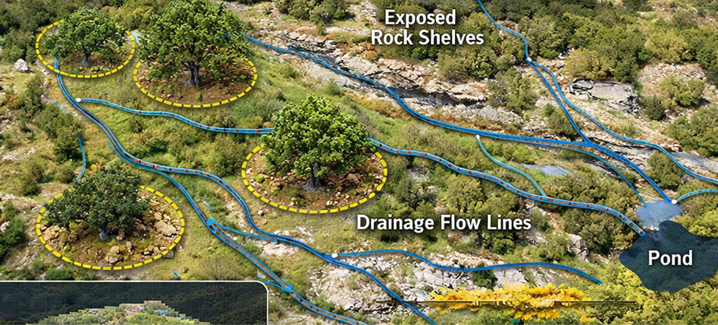
Show RTK drone flight over Wasatch foothills structure, gamble oak/sagebrush terrain.
Cut to vegetation density map generating in Pix4D Cloud. Cut to compliance report PDF.
PRODUCTION NOTE: Summit or Wasatch County location. 60–90 sec. No narration required — text overlay sufficient. ]
Don't guess whether your property is compliant
FROM THREAT MAPPING TO
COMPLIANCE DOCUMENTATION
WE MAP THE FUEL LOAD
BEFORE ANYTHING MOVES.
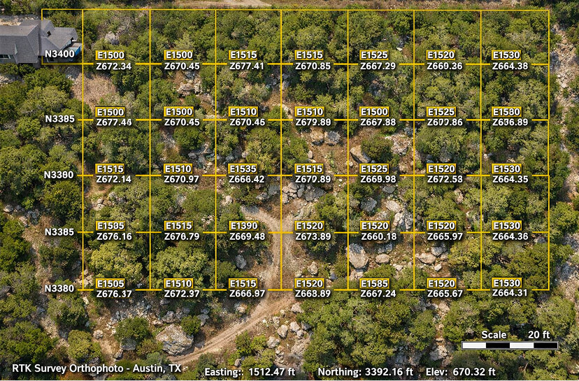
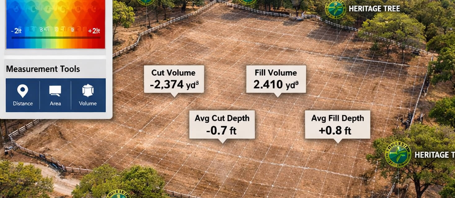
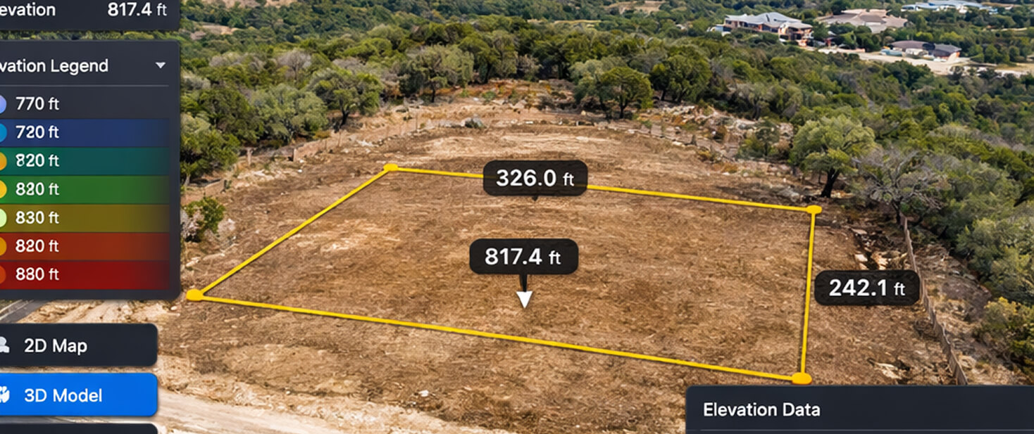
The DJI Mavic 3 Enterprise RTK drone maps your property to ±0.5cm accuracy — producing a vegetation density model that shows exactly where fuel load is highest, how close it sits to your structure, and where the highest-risk fire approach vectors are. This isn't an estimate. It's a photogrammetric model of your actual land conditions, referenced to real-world coordinates.
Technical: Orthomosaic at 1.5–2cm GSD, DSM for canopy height, NDVI-adjacent vegetation index mapped to structure proximity. Emlid RS3 base station provides absolute accuracy for georeferencing. Output integrates with Pix4D Cloud Advanced for 3D model generation.
Inside WUI High-Risk Boundary
2026
Effective Date
Accuracy
Post-Assessment Flight
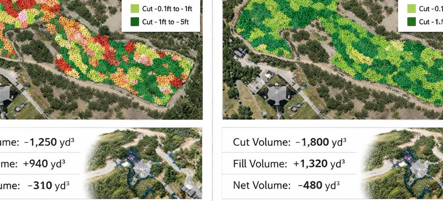
We fly the property, map every fuel load zone to within half a centimeter, and produce a defensible space report that your insurance carrier can use directly. When the clearing's done, we fly again and prove the distances — in 3D, with GPS coordinates. That's not something a brush crew with a tape measure can give you.
— ClearGround · The Ground, Verified. · Summit & Wasatch Counties, Utah
HB 48 — What You Need to Know
Utah's Wildland Urban Interface Modifications Act (effective January 1, 2026) mandates annual fees of $20–$100 for every structure inside the state-designated high-risk WUI boundary. Fees are assessed automatically through property tax. They can be reduced to zero through documented defensible space compliance — but only with verified documentation. The Utah Division of Forestry, Fire and State Lands (FFSL) provides free lot assessments to help homeowners understand their status. Those assessments identify the problem. ClearGround fixes it and proves it was fixed.
Book Your Free
Site Scan.
Every project starts with an RTK drone scan of your site. We fly it, build your 3D model, and deliver a fixed-price proposal — all before you commit to anything.
Book Site Scan Call TX Office (512) 880-8888 Call UT Office (801) 909-0000HB 48 Compliant Documentation · RTK Verified · Summit · Wasatch · Salt Lake Counties