TX contractor LIC
UT contractor INS
FAA PART 107 FAA 107
Insurance $2M GL
Pricing Technology About Contact
Civil Engineering Firms

SURVEY-GRADE DATA.
48 HOURS.

Your survey crew takes four weeks to mobilize. Your as-built data doesn't integrate into CAD/BIM. Your client deadline isn't moving. We scan before we dig. We prove what we move. Georeferenced point clouds and as-built models in your inbox — not on a four-week backlog.

Book a Free Site Scan

    Request a Quote

    Send us a message for a free quote. We aim to respond within 1 business day to all inquiries.

    Austin Metro · Round Rock
    Cedar Park · Georgetown · San Marcos
    The Problem You Already Know
    01

    Your survey backlog is killing your timeline.

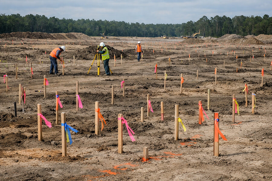
    Traditional survey crews take 3–4 weeks to mobilize. Meanwhile, your design schedule doesn't pause. You're making assumptions about existing conditions that won't be verified until it's too late to change the plan — and too expensive to redesign.

    02

    As-built data that doesn't integrate.

    You receive a PDF scan and a field sketch. Now someone on your team has to manually translate that into your BIM model. Every hand-off introduces error. Every error creates rework. You need georeferenced data that drops directly into your CAD/BIM workflow — not another document to interpret.

    03

    Disputed quantities. Client disputes.

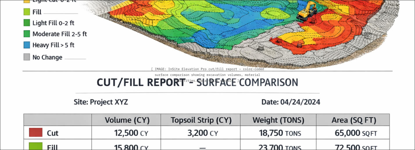
    When volumetric estimates don't match final bills, you're the one explaining the discrepancy to your client. You need a verifiable system of record — one that measures what was actually moved, not what was guessed at before mobilization.
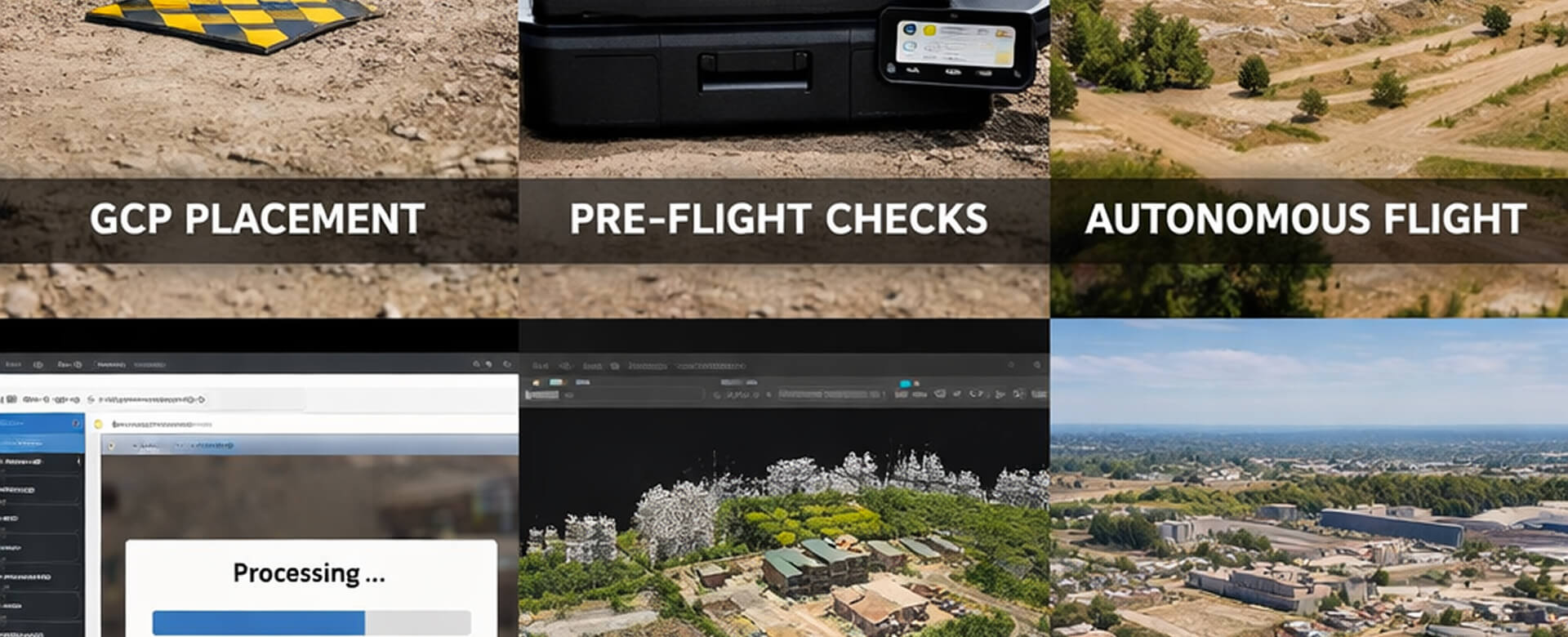
    Your Data, Step by Step

    FROM FIELD REQUEST
    TO CAD/BIM. 48 HOURS.

    Rapid-deployment RTK survey and processing. One call, one mobilization, one deliverable in your file format. No backlog. No interpretation layer.

    01
    Field Request
    You need topo, as-built, or volumetric data. We mobilize within 48 hours of your call — not 4 weeks.
    02
    RTK Drone Survey
    DJI Mavic 3 Enterprise RTK captures the site to ±0.5cm accuracy. FAA Part 107 certified pilot. Ground control verified.
    03
    Processing
    Point cloud generation, orthomosaic stitching, and volumetric analysis via DroneDeploy and InSite Elevation Pro.
    See the technology →
    04
    Delivery
    Georeferenced files in your preferred format — .dwg, .rvt, point cloud, or web viewer. Ready for your BIM workflow.
    05
    Integration
    Drops directly into your CAD/BIM environment. No interpretation layer. No manual translation. Coordinate-ready.
    View data specs →
    Traditional
    ClearGround
    Don't wait four weeks for data you can have tomorrow

    AT ANY PHASE OF YOUR PROJECT
    GET AN UNBIASED VIEW OF YOUR SITE

    Existing Conditions
    PHASE 01 — BEFORE THE FIRST BUCKET

    CENTIMETER-ACCURATE TOPO. BEFORE DESIGN.

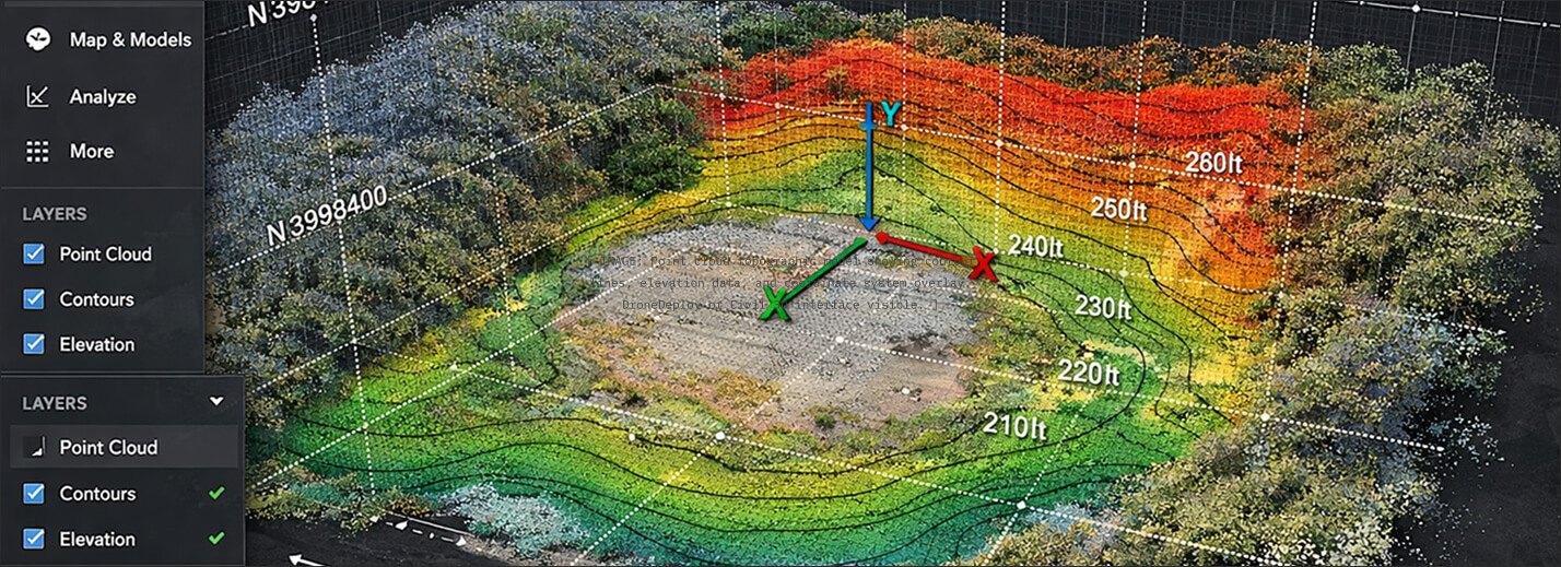
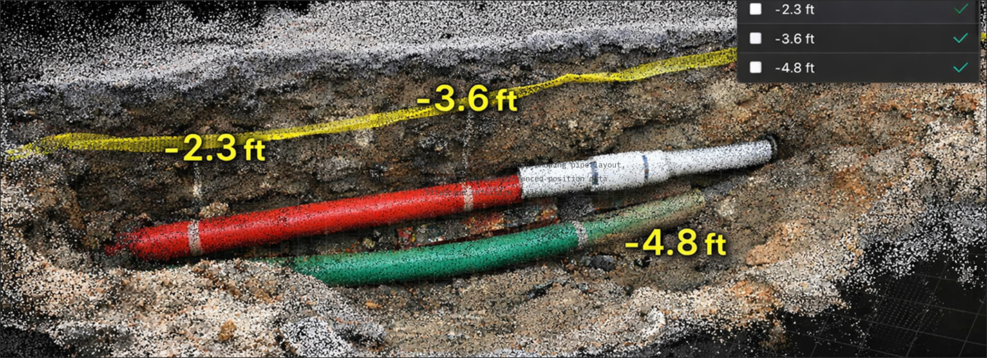
    Your design starts with data, not assumptions. We deploy a Mavic 3 Enterprise RTK drone that captures the full site to ±0.5cm accuracy — topo, vegetation, existing utilities, drainage patterns. Delivered as a georeferenced point cloud that drops directly into your CAD environment. No waiting for a survey crew to schedule.

    ± 0.5CM ACCURACY · GEOREFERENCED POINT CLOUD · ORTHOMOSAIC · CONTOUR GENERATION · CAD-READY EXPORT
    1/5
    2/5
    3/5
    4/5
    5/5
    Data Deliverables

    SPECS, NOT PROMISES.

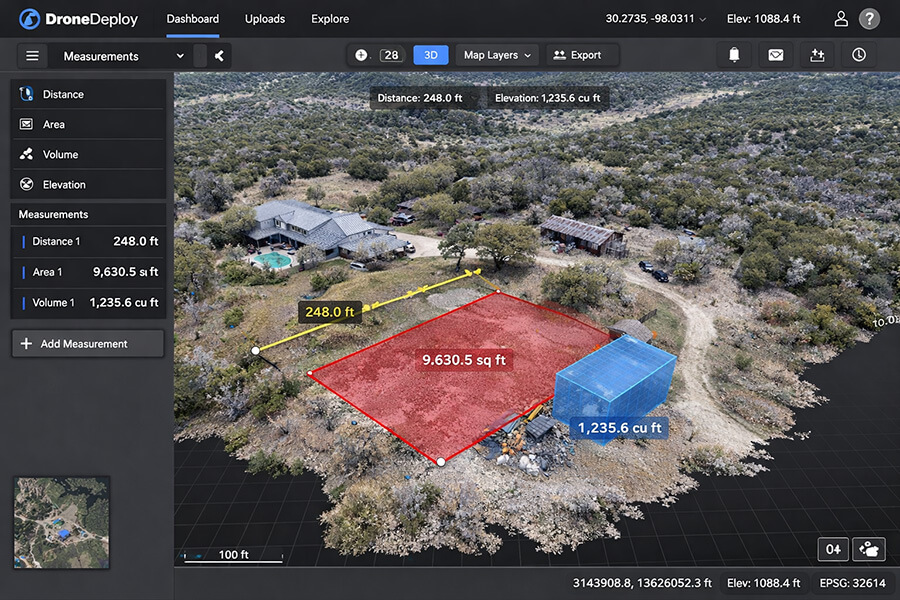
    Every ClearGround project produces structured, georeferenced data deliverables — not marketing materials. These are the datasets your team integrates into active design and construction workflows.

    Deliverable 01
    3D Digital Twin
    Georeferenced orthomosaic and point cloud model generated via DJI Mavic 3 Enterprise RTK. Full-site capture with centimeter-level horizontal and vertical accuracy. Hosted on DroneDeploy with measurement, annotation, and sharing tools.
    Output: Point Cloud · Orthomosaic · 3D Mesh
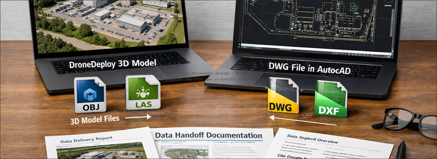
    Formats: .las · .laz · .tif · .obj
    Platform: DroneDeploy Web Viewer
    Deliverable 02
    Earthwork Volumetrics
    Quantified cut/fill reports generated via InSite Elevation Pro. Verified against initial RTK baseline scans. System-of-record grade — in billing disputes, this data is the answer. Exportable and auditable.
    Output: Cut/Fill Report · Surface Comparison
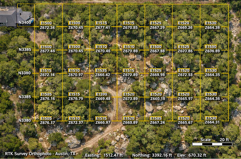
    Formats: .pdf · .csv · .xml
    Platform: InSite Elevation Pro
    Deliverable 03
    CAD/BIM Export
    Georeferenced files formatted for direct integration into your design environment. Topo surfaces, as-built models, and subsurface documentation delivered coordinate-ready. No manual translation required.
    Output: Surfaces · As-Builts · Subsurface Models
    Formats: .dwg · .rvt · .ifc
    Platform: AutoCAD · Revit · Civil 3D
    View Full Technology Specs Request Pre-Qual Packet
    By the Numbers
    ±0.5cm
    RTK Survey Accuracy
    48hr
    Mobilization to Your Site
    .dwg
    Native CAD/BIM Delivery
    "

    Georeferenced LiDAR and photogrammetry delivered as-built. Integrates directly into CAD/BIM. We mobilize in 48 hours, not 4 weeks. We're the field data arm you don't have to hire.

    — ClearGround · The Ground, Verified.
    [ PLACEHOLDER: Replace with civil engineering firm testimonial after first data partnership project ]

    WE LET THE DATA SPEAK FIRST.

    Request a sample dataset. We'll show you exactly what a ClearGround deliverable looks like — point cloud, volumetric report, and CAD export — before you commit to anything. No sales pitch. Just data.

    Sample Dataset Available · No Obligation · FAA Part 107 Certified