EVERY YARD BILLED
IS A YARD PROVEN.
Hyperscale data centers don't pause for sub no-shows, ESC failures, or documentation gaps. ClearGround delivers mass clearing, grading, and utility trenching across the Austin–San Antonio corridor — with every cubic yard RTK-verified and handed to your owner as a CAD/BIM-native digital twin. Not a binder of sketches. An audit trail.
Your site prep sub fell off the critical path.
Mass clearing slipped two weeks. Mass grading is short three pieces of iron. Your pad delivery window for the first power skid is closing, and the owner's commissioning team is starting to ask questions. The sub said they'd "catch up." They won't.
ESC failure brought TCEQ to the site.
Heavy rain. BMPs blew out. Sediment hit the receiving water. Now an inspector is on site, the SWPPP file is being audited, and the documentation trail you thought you had is a stack of crumpled paper inspection sheets in someone's truck.
The owner wants the audit trail. You don't have one.
Pay app comes back for cut/fill verification. Your sub measured with a tape and a laser. The owner's engineer wants RTK-grade as-builts in CAD/BIM-native formats. You're now backfilling documentation for work that was already paid.
MASS WORK. MILLIMETER PROOF.
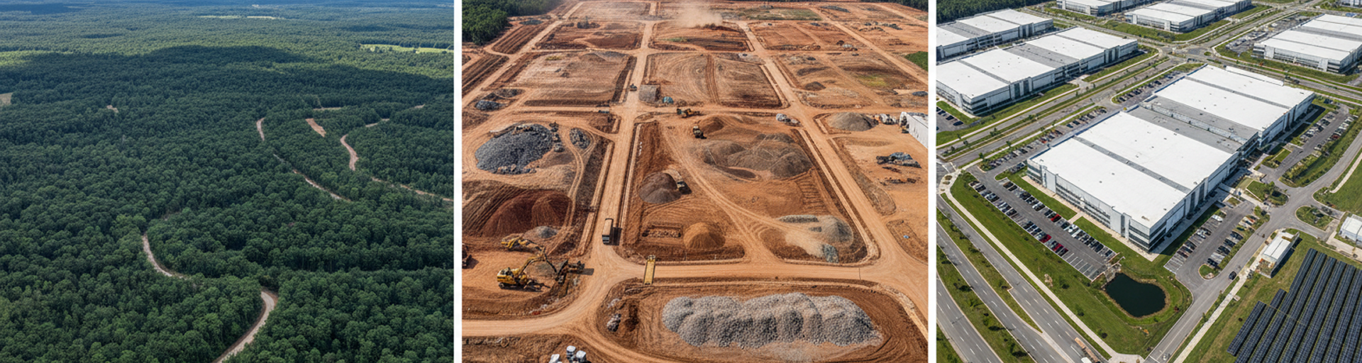
From greenfield acreage to foundation-ready pad — six phases, one crew, RTK-verified at every milestone. Your owner gets the audit trail. Your GC gets predictable pad delivery. Your commissioning team gets the as-builts.
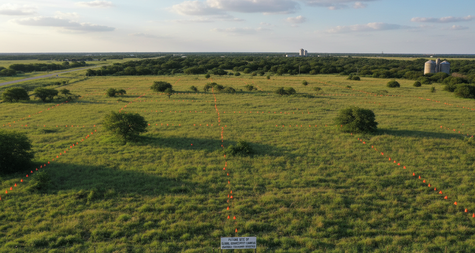
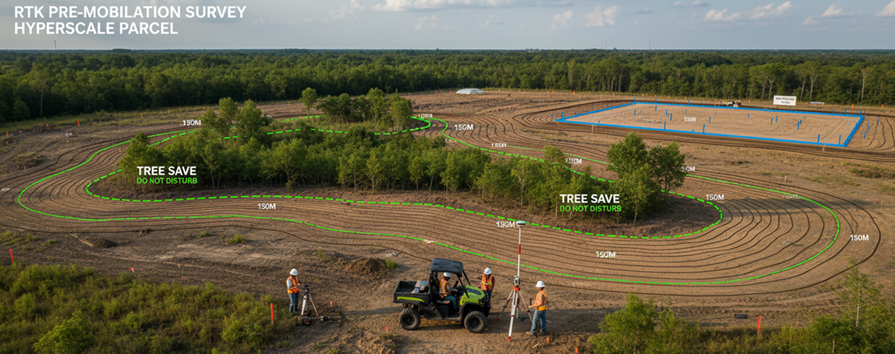
Full-site orthomosaic + topo to ±0.5cm before mobilization. Existing conditions documented. Tree-save zones GPS-staked.
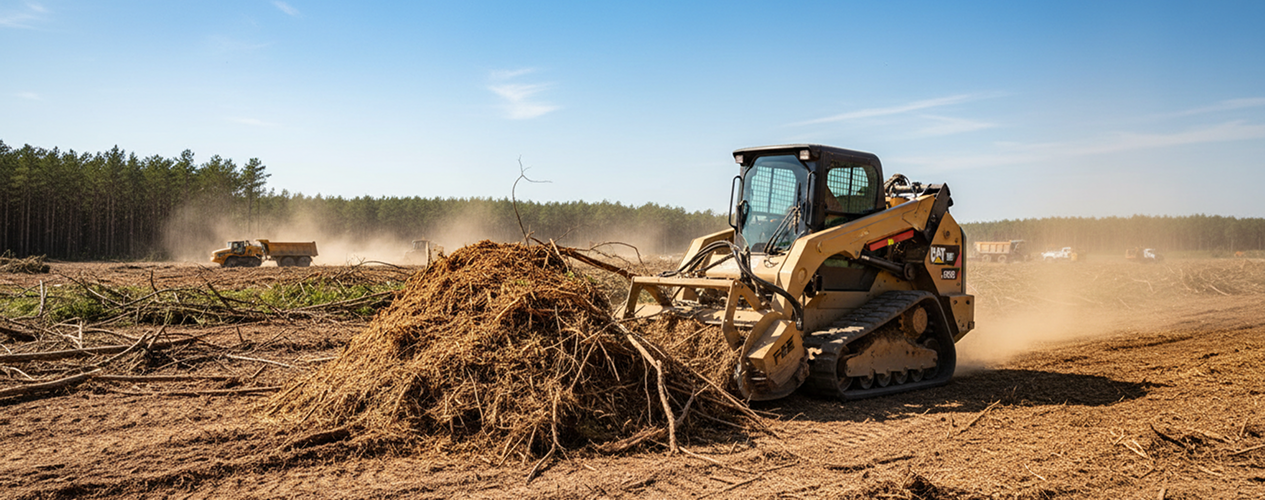
FAE forestry mulcher on CAT 299D3 XE — multi-acre clearing with no haul-off when feasible. Topsoil segregated to spec.
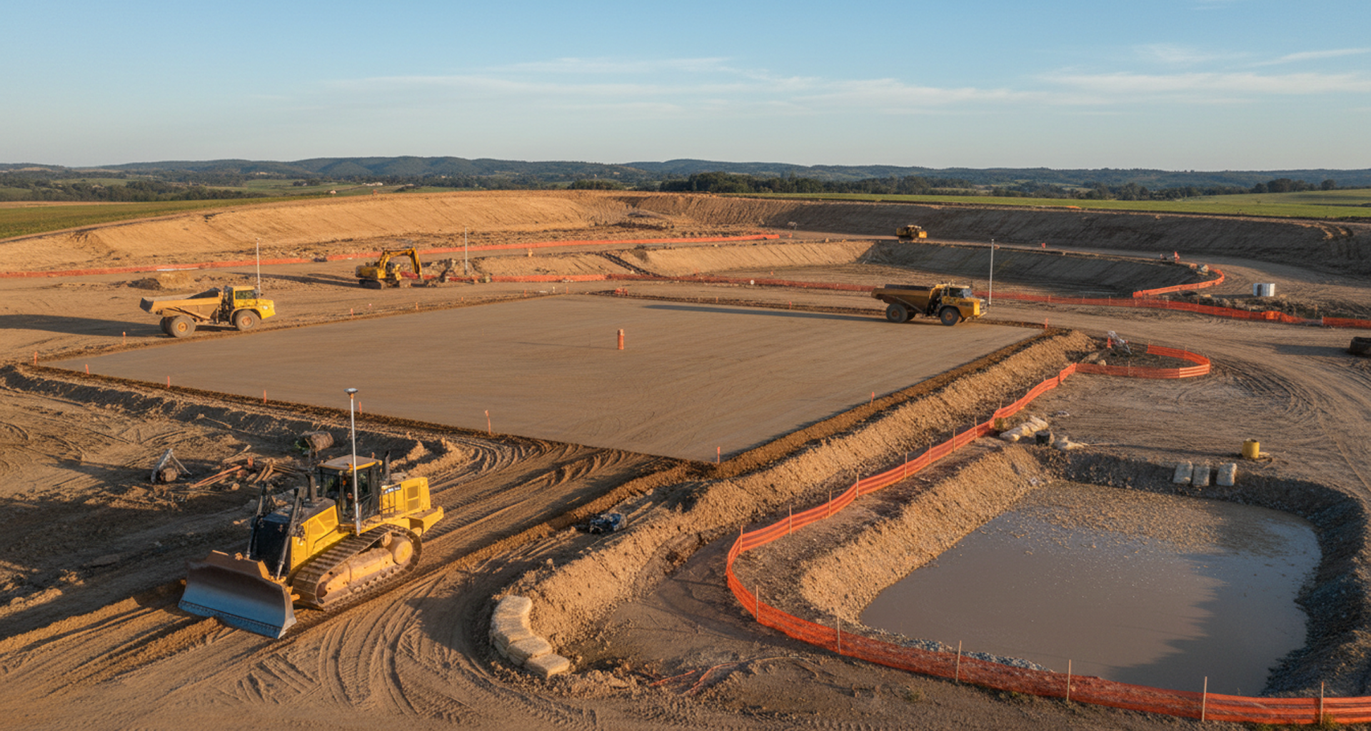
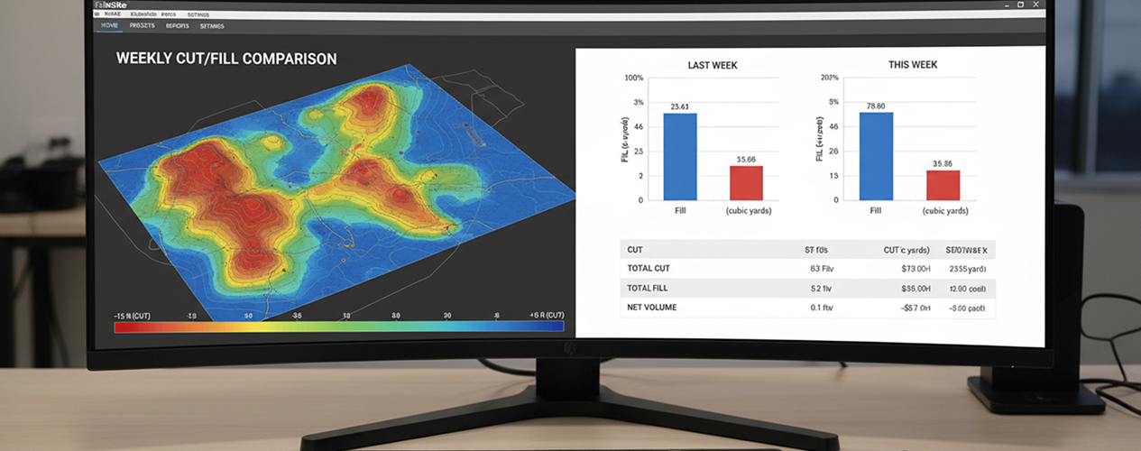
Cut/fill to engineered plan with RTK + machine control. Daily volumetric reports via InSite Elevation Pro.
Generator pads, fiber routes, power skid foundations. LiDAR subsurface scan before backfill.
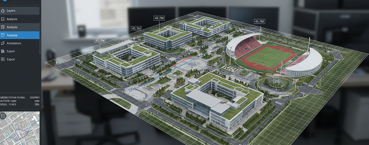
Every Friday — georeferenced 3D model on DroneDeploy. Progress, ESC, and CY-billed visible to your owner.
.dwg / .rvt / point cloud + interactive viewer. Owner-grade documentation ready for commissioning.
AT EVERY PHASE OF YOUR BUILD
EVERY CUBIC YARD IS VERIFIED.
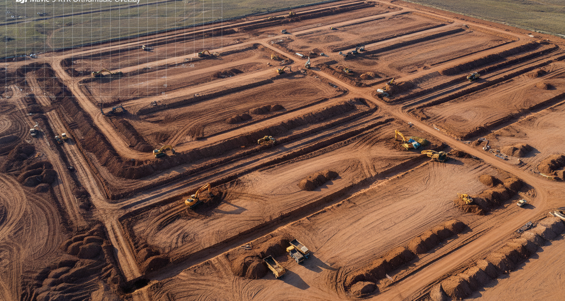
WE SCAN THE SITE
BEFORE WE BREAK GROUND.
DJI Mavic 3 RTK delivers a survey-grade orthomosaic and topo to ±0.5cm before a single piece of iron mobilizes. Existing conditions, tree-save zones, drainage flow, and parcel boundaries are documented and shared with your engineer the same day. Your bid documentation gets the verification layer most subs can't deliver.
CAT 299D3 + FAE
MULTI-ACRE PER SHIFT.
Mass clearing without haul-off. FAE forestry mulcher converts vegetation to on-site mulch — topsoil segregated to spec, restoration-ready material stockpiled. CAT 308E2 CR handles tight setbacks around existing power, fiber, and pre-existing site features. Compact + full-size fleet, one operator culture.
WEEKLY DIGITAL TWIN.
CRITICAL PATH VISIBLE.
Every Friday, your owner, your engineer, and your commissioning team receive a georeferenced 3D model on DroneDeploy. InSite Elevation Pro generates the cut/fill audit alongside it — exact CY moved, billed, and verified. ESC inspections run on the same RTK platform, with weekly imagery that's TCEQ-defensible.
PAD-READY.
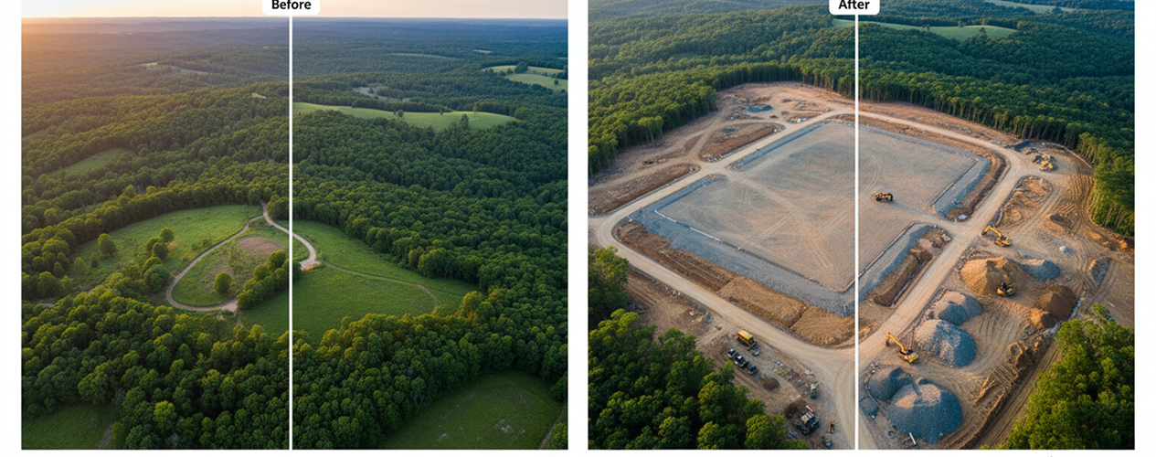
DOCUMENTED, NOT ASSUMED.
Your foundation contractor doesn't inherit guesswork. They inherit a georeferenced as-built showing the finished surface, sub-grade compaction notes, conduit and utility trench as-builts with LiDAR pre-backfill scans, and a cut/fill total that ties to every approved pay app. The audit trail is the deliverable.
YOUR CAMPUS,
VERIFIED IN 3D.
A georeferenced 3D model of the entire campus — before, during, and after site prep — exported in CAD/BIM-native formats and delivered via shareable DroneDeploy viewer. Your owner's commissioning team works from the same dataset your GC built from. No translation layer. No "we'll figure it out at handoff."
ONE SUB. EVERY EARTHWORK SCOPE.
Stop coordinating clearing + grading + trenching + survey + ESC across four subs and a separate drone company. ClearGround bundles all of it under one MSA — one crew, one scan, one documentation stream.
Mass Clearing & Mulching
Multi-acre clearing with FAE on CAT 299D3 XE. On-site mulch + topsoil segregation. Zero haul-off when feasible. ESA tree-save zone GPS-staked.
Mass Grading + Bedrock Excavation
Cut/fill to spec with RTK + machine control. Hydraulic hammer for limestone bedrock. On-site rock milling for aggregate reuse.
Utility & Conduit Trenching
Generator pads, fiber routes, power skid foundations, cooling-pond inflows. LiDAR subsurface scan before backfill — every linear foot georeferenced.
RTK + Digital Twin Audit
Weekly DroneDeploy progress twin + InSite volumetric audit + TCEQ-defensible ESC inspection. CAD/BIM-native as-built at handoff.
We scan the entire site before mobilization. Every cubic yard moved is georeferenced and verified. Your owner gets the audit trail. Your GC gets predictable pad delivery. Your commissioning team gets RTK as-builts in CAD/BIM, not a binder of paper sketches.
— ClearGround · The Ground, Verified.
SEND US THE SCOPE.
WE'LL SEND THE PREQUAL.
Active on the Austin–San Antonio corridor — Williamson, Caldwell, Bell, Travis. Mobilizing to Abilene, Laredo, and West Texas for the right scope. Prequal packet includes COI, EMR, equipment list, RTK deliverable samples, and references.
Request Prequal PacketISN · Avetta · BuildingConnected · Tract / Sabey / Blueprint vendor portals