TX contractor LIC
UT contractor INS
FAA PART 107 FAA 107
Insurance $2M GL
Technology About Contact
LC.01 — Land Clearing / Sub-Service

Full site clearing.
Every acre.
One mobilization.

Multi-acre lot clearing in the Austin metro and Texas Hill Country — cedar, live oak, limestone, stumps, and brush — grubbed to bare dirt and verified to construction-ready spec. The whole property in a single mobilization.

15
Acre Range / Project
25
Day Typical Timeline
±0.5cm
RTK Grade Accuracy
3D
Digital Twin Delivered
What This Is

Total site clearing.
Bare dirt to spec.

Full site clearing is exactly what it sounds like: the entire property, cleared to construction-ready grade in a single mobilization. Vegetation removed. Stumps grubbed below surface. Surface limestone milled in place. Every acre documented, verified, and handed off with a 3D digital twin your next trade can actually use.

This service is built for properties where partial clearing isn't an option — new-build homesites, large infill parcels, multi-acre pool and estate projects, and previously undeveloped land that needs a total reset before anything gets built. One crew, one scan sequence, one handoff package.

Where other clearing contractors run a machine through and hand you a bill, ClearGround runs an RTK drone survey before the first pass and after the last one. The result is a verified before/after record that eliminates disputes, proves grade compliance, and documents every heritage tree boundary that was honored.

Vegetation
All Woody Vegetation Removed
Cedar, live oak, mesquite, post oak, persimmon, and all invasive brush — cut, processed, and mulched in place or removed. Trees to specified size (typically up to 12" DBH) included in base scope.
Root Systems
Stump Grubbing to Construction Depth
Stumps grubbed below surface to construction-ready spec — not flush-ground. Root balls extracted and processed on-site. Void left by grubbing is backfilled to grade so the pad is stable from day one.
Rock & Geology
Limestone Milled On-Site
Surface limestone and caliche rock processed in place with the FAE rock crusher — turned into engineered aggregate that becomes road base, drainage material, or foundation fill. Zero haul-off cost.
Protected Trees
Heritage Trees Flagged & Preserved
Austin Heritage Tree Ordinance compliance built into the plan. CRZs mapped before clearing begins, arborist coordination arranged, and every protected tree documented with pre/post RTK scans for city review.
Grade
Rough Grade to Drainage Plan
Cut and fill to the engineered drainage specification — verified to ±0.5cm with RTK data. Drainage flow lines confirmed before handoff. Not a gut-feeling grade: a measured, documented surface your team can build on.
Documentation
3D Digital Twin Delivered
DroneDeploy 3D model, georeferenced orthomosaic, and elevation report delivered within 48 hours of completion. Shareable with your GC, civil engineer, pool builder, or city reviewer. Permanent, measurable, not a PDF.
Standard Site Clearing
Schedule based on guessed acreage complexity
Rock surprises halt work — day rate burns
Heritage tree discovered after clearing begins
Grade eyeballed — first drainage review fails
No documentation for GC, engineer, or city
Debris haul-off adds $35–65/CY to project
VS
ClearGround Full Site Clearing
RTK scan reveals all variables before mobilization
Rock milled on-site — no haul-off, no surprise cost
CRZ flagged from first drone flight
Grade RTK-verified to ±0.5cm — drainage passes
3D digital twin delivered within 48 hrs
Zero-waste processing — debris becomes asset
Pricing
Acreage is the starting point, not the final number. Full site clearing quotes are built from what the pre-scan actually shows: vegetation density, rock extent, slope, heritage tree count, and access constraints. The ranges below reflect real project costs in the Austin and Hill Country market. The pre-scan quote you receive is based on data, not a windshield estimate.
FSC.01

Full Vegetation Clear
& Grub

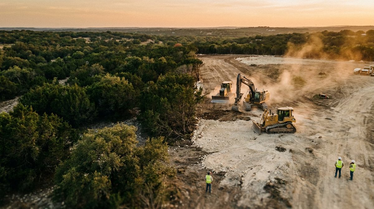
All trees, brush, and root systems removed to construction-ready specification across the full property. The CAT 299D3 XE with FAE mulching head processes vegetation in place — cutting, chipping, and distributing organic material as a nutrient layer or removing it to stockpile for disposal. Stumps are grubbed below the surface, not ground flush — because a construction-ready lot has no stump remnants to compromise the pad.

CAT 299D3 XE + FAE Mulching Head · CAT 308E2 CR (grubbing)
Trees to 12" DBH included · Larger trees quoted on-site
Multi-acre scope · Single mobilization
$2,500 – $4,500 / acre
Multi-acre full site clearing in Austin metro and Hill Country. Total project minimum ~$6,000.
What drives the price up: Vegetation density is the dominant variable. An open Hill Country lot with scattered cedar and native grass clears far faster than a heavily wooded 2-acre parcel with multi-trunk live oak clusters and dense cedar thicket. Tree size matters: trees under 6" DBH process quickly through the mulching head; 8–12" trees require repositioning and slower passes. If the property has significant thorn brush (huisache, catclaw acacia, greenbrier), clearing slows and protective equipment time adds cost. Debris removal — when the client wants organic material trucked off rather than mulched in place — adds roughly $30–$50 per cubic yard of material moved.
[Before/After Photo Set] Multi-acre Austin or Hill Country property. Drone aerial: before (dense cedar/brush) vs. after
FSC.02

Heritage Tree Boundary
Management

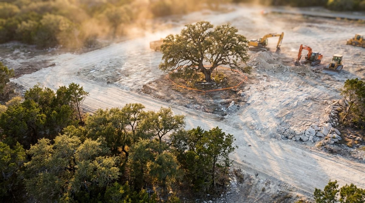
On multi-acre site clears, Austin's Heritage Tree Ordinance doesn't get simpler — it gets more complex. More land means more trees. More trees means more Critical Root Zones. More CRZs mean more opportunities to trigger a violation that stops your project and hands you a $5,000–$50,000 fine. ClearGround maps every protected tree's CRZ from the pre-clear drone scan, flags boundaries on-site before clearing begins, and documents the before/after condition so city review has the evidence package it needs.

DJI Mavic 3 RTK Pre-Clear Canopy Survey
CRZ Flagging (physical + digital boundary)
Pre/Post Documentation Package for City Review
Arborist Coordination — coordinated at cost
$600 – $1,800 / tree
Per protected tree, depending on CRZ complexity and proximity to clearing zone. Often bundled into overall site clearing scope.
What drives the price up: Trees whose CRZ overlaps the clearing zone require the most precision — the machine operator is working within 6–10 feet of the boundary line in some cases. Trees in clusters with overlapping CRZs are the hardest: the machine can't make a clean pass and has to navigate slowly between them. Arborist coordination (required for some permits) is passed through at cost and typically ranges $150–$400 per tree for assessment and documentation. When a protected tree is in a location that would require clearing to route around it significantly, access constraints may affect the overall clearing timeline.
[Heritage Tree Boundary Photo] Aerial view showing CRZ flagging on a live oak during active site
FSC.03

Rock Identification
& On-Site Milling

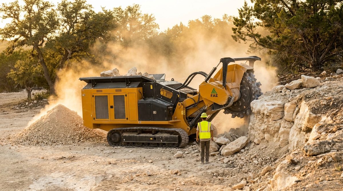
The Hill Country's Edwards Plateau limestone isn't an obstacle — it's a material. The pre-clear RTK scan maps surface rock extent before the first machine moves. That data determines which areas get milled in place with the FAE rock crusher, which require hydraulic hammer excavation, and which can be graded around. Limestone that stays on-site costs you nothing to remove — and becomes engineered base material for your driveway, drainage aggregate, or retaining wall backfill.

Pre-Clear Rock Mapping via RTK Survey
FAE Rock Crusher — mills to 4–6" depth
CAT 308E2 CR + Rock Hammer (deeper rock)
Crushed material: aggregate / road base / drainage fill
$2,000 – $5,500 / acre
Rock milling scope billed separately from clearing when rock is significant. Light scatter rock may be included in clearing base rate.
What drives the price up: Rock depth is the main variable — a thin 2-inch limestone cap processes quickly, while a 5–6" shelf of hard Edwards formation takes 2–3 times longer per square foot. Rock hardness varies by formation and age; older cap rock mills slower than younger surface caliche. Embedded boulders require the excavator and rock hammer rather than the FAE, which changes the rate. The calculus always favors on-site processing: every cubic yard milled saves $35–$65 in haul-off and tipping fees that a traditional clearing crew passes straight to the client.
[Rock Milling Photo] FAE rock crusher processing Hill Country limestone shelf on a cleared lot. Show
FSC.04

Rough Grade to
Drainage Plan

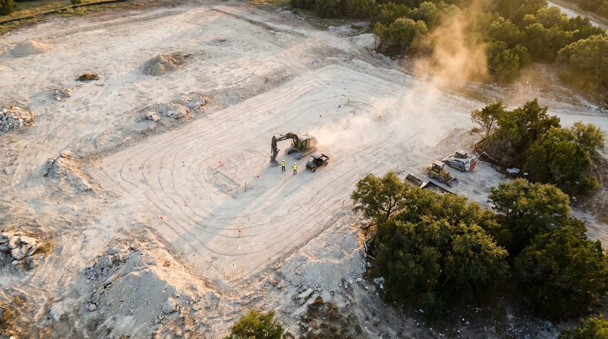
Clearing is phase one. Grading is the handoff. After the site is cleared, the CAT 308E2 CR executes cut and fill operations to reach the engineered drainage plan elevation — then the drone flies again. The post-grade RTK scan confirms that every flow line is where it needs to be, to the centimeter. Your civil engineer gets a grade verification report, not a hope.

Cut/Fill to Engineered Drainage Plan
RTK Post-Grade Verification — ±0.5cm accuracy
Grade Confirmation Report Delivered with Digital Twin
Flow Lines Confirmed Before Handoff
$1,500 – $5,000
Per project, based on grade change magnitude and drainage complexity. Significant savings when bundled with full site clearing scope.
What drives the price up: Properties with significant natural slope — common in the Hill Country — require more material movement to achieve positive drainage away from structure footprints. Multi-directional drainage plans with swales, retention features, or engineered channels take longer to execute precisely than a simple single-slope residential grade. If the drainage plan requires a significant volume change on a large multi-acre parcel, cut/fill volumes become a major cost driver. When grading is bundled with the full site clearing scope (one mobilization, one crew), it's consistently more efficient than scheduling it as a separate event.
[Grading + Digital Twin Photo] Split image: CAT 308E2 CR grading in the field + DroneDeploy
Illustrative — representative visualization
Included in Every Full Site Clearing Project

Pre-clear RTK drone survey, heritage tree CRZ mapping (when applicable), real-time progress photo documentation, and as-built 3D digital twin delivery within 48 hours of project completion. The documentation package that other clearing contractors charge extra for — or don't offer — is standard on every ClearGround project. You're not paying for clearing hours. You're paying for a documented, verified, construction-ready site your entire team can rely on.

Pricing Reference

What does it cost to clear
your acreage?

Property Size Vegetation Type Estimated Range
0.5 Acre Light to medium brush $3,500 – $5,500
1 Acre Mixed cedar / live oak $5,500 – $9,000
1 Acre Dense cedar thicket $8,000 – $12,000
2 Acres Mixed vegetation $10,000 – $18,000
3 Acres Mixed + rock milling $16,000 – $26,000
5 Acres Full site prep scope $25,000 – $45,000

Ranges include clearing, stump grubbing, and rock milling. Heritage tree management, rough grading, and debris removal are quoted per-project. Actual cost determined by pre-clear RTK scan data.

Why ranges, not flat rates

Full site clearing pricing can't be flat-rated because two properties of the same acreage can be 3x apart in real cost. A 2-acre lot in Westlake with a dozen 10" live oaks and a limestone shelf is a completely different job than a 2-acre cleared-once ranchette lot in Marble Falls with open native grass and scattered mesquite.

The pre-clear RTK scan eliminates the guesswork. The drone flies the property, maps vegetation density, identifies rock extent, and locates any heritage trees. That data builds a quote that's based on what's actually there — not what the client thinks is there from a walk-through, and not a contingency-padded number based on worst-case assumptions.

The scan costs nothing. The certainty it produces is the point.

The ClearGround Difference

The scan happens
before the
machine moves.

Most site clearing contractors operate on assumptions. They eyeball the property, estimate the vegetation, and give you a number. When rock shows up where they didn't expect it, that's a change order. When a heritage tree gets too close, that's a problem. When the grade doesn't drain right, that's your issue.

ClearGround builds the pre-clear drone survey into the standard process — not as an upsell, but because the data is what makes the quote accurate and the work verifiable. The RTK scan maps the site in 3D before anything moves. That data drives the plan, informs the quote, and becomes the baseline for the post-clear verification scan that proves the work is done to spec.

Pre-Clear RTK Scan
Every variable mapped before iron moves. Rock extent. Heritage tree CRZs. Slope and drainage flow. Vegetation density by zone. What other crews guess at, we measure.
Single Mobilization
Clearing, milling, grubbing, and grading in one site visit. Equipment comes once. Crew mobilizes once. You get one invoice and one handoff package.
Zero-Waste Processing
Nothing leaves the site that doesn't have to. Vegetation is mulched in place. Rock is milled on-site. Every cubic yard processed on-site saves $35–$65 in haul-off fees.
Post-Clear Verification
Grade confirmed to ±0.5cm after the last pass. As-built digital twin built from post-clear scan data. Delivered to your team within 48 hours — shareable, permanent, court-admissible.
Handoff Package
3D model on DroneDeploy, georeferenced orthomosaic, and grade report. Your GC, civil engineer, pool builder, and city reviewer all get the same verified data set. Not a PDF. A live model.
How Full Site Clearing Works

Five phases.
One verified result.

Full site clearing follows a defined sequence — not because we like process documents, but because sequence is what makes the verification meaningful. The pre-scan before phase one is what makes the post-scan in phase five provable. Skipping either end breaks the chain.

On multi-acre projects: phases 02–04 run simultaneously across zones. The drone doesn't wait for the full property to be cleared before verifying completed sections. Progress documentation happens continuously. Timeline for a 3-acre full site clear typically runs 3–5 days depending on vegetation density and rock extent.
Phase 01
RTK Site Survey
DJI Mavic 3 RTK flies the full property before any equipment is mobilized. Orthomosaic, point cloud, and 3D model captured. Heritage trees located and CRZs mapped. Rock zones identified. Drainage modeled. Quote confirmed or adjusted from data.
DroneDeploy · ±0.5cm accuracy
Phase 02
Heritage Tree Flag & CRZ Boundary
Protected trees physically flagged on-site against the drone-mapped CRZ boundaries before the first machine pass. Arborist coordination completed if required. No clearing begins until every protected tree boundary is confirmed on the ground.
Austin Heritage Tree Ordinance
Phase 03
Full Site Clear & Grub
CAT 299D3 XE processes all vegetation — trees, brush, and understory — with the FAE mulching head. Stumps grubbed below surface with the CAT 308E2 CR. Organic material mulched in place or stockpiled. Rock zones handed off to Phase 04.
CAT 299D3 XE + CAT 308E2 CR
Phase 04
Rock Milling & Grade
Surface limestone milled with FAE rock crusher attachment. Deeper rock excavated with hydraulic hammer. Cut/fill grading executed to drainage plan. Crushed rock distributed as on-site aggregate or removed if excess. Grade set to spec.
FAE Crusher · CAT 308E2 CR
Phase 05
Post-Clear Verification & Handoff
Drone flies the completed site. Post-clear orthomosaic and 3D model compared to pre-clear baseline — every cubic yard accounted for. Grade report confirms drainage spec compliance. Digital twin delivered within 48 hours.
As-Built Twin · 48hr Delivery
Who This Is For

If something gets built after,
this is your phase one.

Pool & Estate Builders

Westlake · Lakeway · Spicewood · Dripping Springs

Your dig crew is booked. Your client is ready. The lot is not. Full site clearing is the phase that gets the property to the state where pool excavation can start without mystery rock, undiscovered stumps, or heritage tree exposure issues stalling the project. ClearGround scans the site, clears and mills in one mobilization, and hands off a verified 3D model your excavation team can work from directly.

How we work with pool builders

Infill Developers

East Austin · Carr · Ash Creek · South Congress Corridor

Infill lots in Austin are small, constrained, and heritage-tree-dense. Full site clearing on a 0.25–0.75 acre infill parcel is a precision operation — not a bull-through. CRZ compliance has to be built into the plan before clearing begins, and grade verification has to be in the city-review package. One mobilization, one documentation set, one handoff to your GC.

How we work with developers

Estate & Ranchette Owners

Wimberley · Fredericksburg · Marble Falls · Johnson City

Building a custom home on multi-acre Hill Country land? Full site clearing is the first real phase of the project — and the one that sets conditions for everything that follows. Cedar and brush come out. Surface rock gets milled. The building pad gets graded and documented. The digital twin you receive is the first permanent record of what your property looks like, accurately measured, before anything gets built on it.

How we work with estate owners
Equipment

Purpose-built iron for
Hill Country terrain.

CAT 299D3 XE + FAE Mulching Head
Primary — Clearing & Milling
CAT 299D3 XE

High-flow compact track loader with FAE forestry mulching and rock crushing attachment. Handles vegetation processing and surface rock milling in a single machine — the workhorse of every full site clearing project.

HP
110 HP
Operating Weight
11,574 lbs
Rock Mill Depth
4–6 inches
Max Tree Diameter
12" DBH
CAT 308E2 CR Mini Excavator
Primary — Grubbing & Grading
CAT 308E2 CR

Compact-radius mini excavator for stump grubbing, deep rock excavation, and cut/fill grading to drainage plan. Zero tail swing allows close-quarters work near heritage trees and property boundaries without structure risk.

HP
66 HP
Operating Weight
18,101 lbs
Dig Depth
15 ft 2 in
Tail Swing
Zero / Compact
DJI Mavic 3 Enterprise RTK
Survey — RTK Mapping
DJI Mavic 3 RTK

Survey-grade drone with Real-Time Kinematic positioning for centimeter-level accuracy without ground control points. Flies pre-clear and post-clear on every project — capturing the baseline and the verification in the same workflow.

Accuracy
±0.5 cm
Sensor
4/3 CMOS 20MP
Flight Time
45 min
Output
Ortho + 3D Twin
Diamond C Flatdeck + Ram 3500
Transport
Diamond C Trailer

Heavy-duty flatdeck hauling both machines to site in a single trip. The Dodge Ram 3500 dually and wrapped Diamond C trailer are ClearGround's primary brand presence on Central Texas roads.

GVWR
14,000 lbs
Deck Length
22 ft
Tow Vehicle
Ram 3500 Dually
Wrap
Matte Black + Orange
Common Questions

What people ask before
they book the scan.

A 1-acre full site clear with moderate vegetation typically runs 1–2 days. A 2–3 acre property with dense cedar and rock milling scope generally runs 3–5 days. The pre-clear RTK scan gives a much more accurate timeline estimate than acreage alone — vegetation density, rock extent, and heritage tree count all affect machine hours. We don't give a timeline estimate until we have the scan data.
On most full site clearing projects, vegetation is mulched in place — the FAE mulching head processes trees and brush into a fine organic layer that distributes across the cleared surface. This eliminates the cost and logistics of haul-off. For clients who prefer the property cleared of organic material entirely, debris can be stockpiled and removed — this adds approximately $30–$50 per cubic yard of material moved off-site. We discuss this preference before the project starts and factor it into the quote accordingly.
ClearGround produces the RTK documentation package that city review requires — pre-clear canopy survey, CRZ boundary mapping, and post-clear condition documentation showing protected trees were preserved. We coordinate with certified arborists when the permit requires an arborist assessment (cost passed through at cost). The city review filing itself is typically handled by your GC, civil engineer, or land use attorney — but they receive our documentation package to submit with their application.
This is exactly why the pre-clear RTK scan exists. The drone identifies surface rock extent before any equipment moves, which means rock milling scope is known and priced before the project starts — not discovered midway through and added as a change order. Subsurface rock that couldn't be identified from the surface scan is the one genuine variable. If the excavator hits unexpected deep rock during grubbing or grading, we document it immediately, show you the data, and adjust scope with a clear price before continuing. No surprises without notification.
Yes — equipment access is part of what the pre-clear site visit evaluates. The CAT 299D3 XE is 76 inches wide; it needs a minimum path of roughly 8 feet to mobilize on-site. If the property has no existing access, we can typically create a temporary access path during the clearing itself — starting from the road edge and working inward. Properties with significant slope at the entry point, seasonal creek crossings, or constrained easements may require an access solution as part of the scope. This gets identified in the pre-clear evaluation and is factored into the quote.
It depends on what you do with it. For pool builders and general contractors, the as-built digital twin gives the excavation crew a verified topographic baseline — actual measured elevations across the pad, not assumed ones. For civil engineers, the grade report confirms drainage spec compliance before they sign off. For clients dealing with city review, it's the documentation package that demonstrates heritage tree protection. For estate owners who just want to see their property clearly for the first time, it's a permanent record. The twin isn't a sales point — it's the artifact that makes the work verifiable after we leave the site.
There's no hard minimum on acreage, but there is a project minimum of approximately $6,000 — which reflects the mobilization cost of getting two machines to site, running the RTK scan, and completing the work. For very small lots (under 0.25 acres), standard lot clearing under the parent Land Clearing service may be more appropriate. Full site clearing is best suited for properties 0.5 acres and above where the full clearing, grubbing, milling, and grading scope is in play.
Ready to start

The scan is free.
The data is what we sell.

Book a free RTK site scan. We'll fly your property, build the 3D model, map the rock and heritage trees, and give you a quote based on what we actually found — before you commit to anything.

Book Your Site Scan